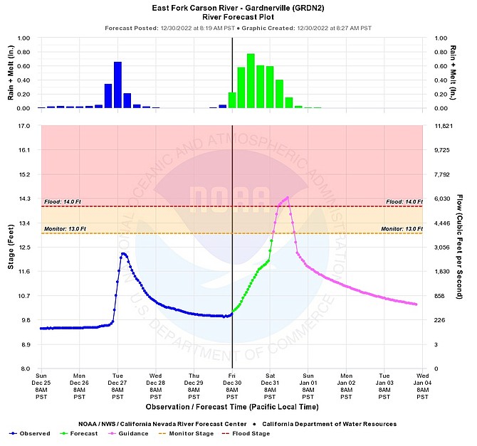
The California Nevada River Forecast Center graph for the East Fork of the Carson River where it enters Carson Valley updated 8:30 a.m. Dec. 30.
River forecasts indicate the East Fork of the Carson River will hit flood stage as it enters the Valley around 7 p.m. Saturday.
Data from the California Nevada River Forecast Center shows the river hitting 14.3 feet, above the 14-foot flood stage starting around 2 p.m. Saturday and then rising quickly over the next five hours.
The forecast issued 2 p.m. Thursday assumes 3 inches of rain falling upstream, according to the center’s web site.
The gauge located just south of Prison Hill in Carson City indicates the river will crest at midnight, which means Willow Bend in Genoa should crest higher around 9-10 p.m., if the forecast holds.
It was already raining on Friday morning as another atmospheric storm arrives in Western Nevada that is predicted to exceed Tuesday’s.
There is a possibility that colder temperatures Saturday could lower snow levels, reducing the potential for flooding, forecasters said Friday morning.
Previous Story
The brunt of a third wet storm in the last week of 2022 was expected to arrive Saturday, National Weather Service forecasters said on Thursday.
“After our recent heavy rains, many watersheds have been primed and will be more prone to flooding with the prolonged and heavy rain expected Friday and Saturday,” said Senior Service Hydrologist Tim Bardsley. “While urban and poor drainage area flooding is likely, and probably worse than what was experienced on Tuesday, small creeks and streams that saw significant rises on Tuesday are likely to rise higher and maintain high flows longer with a greater potential for impacts.”
Bardsley is also predicting major rises on main stem rivers with minor to moderate flooding possible on the East Fork of the Carson River near Gardnerville and on the river through Carson City.
“Confidence is low in how quickly rain-snow lines fall on New Year's Eve leading to a large boom-bust potential of flood impacts vs. snow impacts.”
On Wednesday, Douglas County issued a statement asking residents to be prepared for flooding after a flood watch was issued for Western Nevada for 7 a.m. Friday through 4 a.m. Sunday.
A wind advisory is also in effect from noon Friday through 4 p.m. Saturday.
A winter storm watch takes effect 10 p.m. Thursday at Lake Tahoe. The Sierra Avalanche Center in Truckee has issued a warning for high avalanche danger in the Sierra from Ebbetts Pass north to Yuba Pass.
Should the river rise, the county warns Mottsville, Centerville, Muller and Genoa lanes could close due to flooding.
There may also be flooding downstream from the Tamarack and Numbers burn scars.
The county has released locations for self-fill sandbag locations. Bring a shovel.
• Sheridan Fire Station 980 Sheridan Lane
• Genoa Fire Station 2298 Main St.
• Highland Way at the large water tank (Holbrook Highlands area)
• Johnson Lane Fire Station 1450 Stephanie Lane
• Fish Springs Fire Station 2249 Fish Springs Road
• Ruhenstroth Fire Station 2008 Pinto Circle
• Kahle Community Center (Lake Tahoe)
Additional sites may be added depending on conditions over the next several days and will be posted on the Douglas County Web Site.
Tips for residents:
• Never drive or walk through flooded streets; Turn Around, Don’t Drown! Do not go through flood waters.
• Stay vigilant and aware of your surroundings
• Sign up for Douglas County’s REVERSE 911 service at: https://douglascounty.onthealert.com/Terms/Index/?ReturnUrl=%2f
• Make sure government alerts are turned on in your phone settings
• Stock up on gas and groceries in case of a power outage or road closures in the area
• Check on your neighbors to make sure they are okay or may need help in the event of flooding
• Know what to do before, during, and after a flood.
• Consider the safety of your pets and livestock. If possible move livestock to higher ground.
• Flood insurance takes 30 days to take effect, so purchase now to protect your family
• Listen to local officials by radio, TV or social media, follow the Douglas County Facebook, Twitter or website for updates
• Evacuate when advised by authorities or if you are in a flood or flash flood-prone area.
• If you are on high ground above flooded areas, being prepared to stay where you are may be the best protection.
• Remove yard items that might have the potential for damage.
• Clear away any existing debris which may clog drainage.
Douglas County has activated a webpage for this Flood Incident and the most current information will continue to be posted here: Douglas Updates

Comments
Use the comment form below to begin a discussion about this content.
Sign in to comment