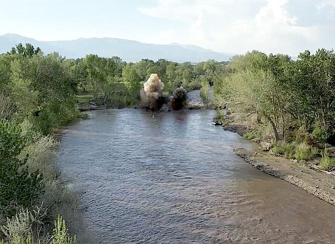
A screen shot from video of the demolition of a diversion dam on the East Fork near Carson Valley Golf Course on Friday taken by J.T. Humphrey
Concerns about flooding along the East Fork of the Carson River led to the demolition of a logjam on Friday.
The jam was located at the diversion dam for the Rocky Slough and Virginia Alderman Canal.
Douglas County and East Fork Fire Protection District had been working at the location for two days in preparation for the demolition.
The East Fork crested at 13.57 feet 2:40 a.m. today at Horseshoe Bend, nearly dead center between the 13-foot action stage and the 14-foot minor flood stage, before beginning to recede.
The West Fork at Woodfords crested at 14.04 feet 9:45 p.m. Friday night, exceeding the minor flood stage of 13.5 feet.
River forecasts show the East Fork of the Carson River possibly hitting minor flood stage of 14 feet around 3 a.m. Sunday as Douglas County urged residents to prepare for high water.
The West Fork at Woodfords is expected to continue bouncing along above the 13.5 foot minor flood.
On Thursday, Douglas County updated its list of sandbag locations with Public Works and East Fork Fire Protection District standing by near spots susceptible to flooding to ensure water continues to flow, spokesman Eric Cachinero said.
Firefighters responded to a report of flooding on Kerry Lane by Carson Valley Golf Course on Wednesday and were back in the vicinity on Thursday.
The Nevada Department of Transportation has stationed excavators by the bridges on Highway 88 and 395 to pluck logs out of the river before they do any damage.
On Friday morning, an excavator was being used to shore up the bank of the East Fork with boulders just upstream of the Highway 88 bridge.
A flood watch that took effect on Thursday night is expected to continue through 8 p.m. Monday.
“The current period of unseasonably warmer temperatures will result in excessive snowmelt and runoff from higher mountain areas into lower elevation locations along the Carson River, Walker River basins and eastern Sierra Basins,” forecasters said. “Creeks, streams and main stem river areas will continue to run high, fast and cold after expiration of the watch.”
The West Fork of the Carson River reached minor flood stage at Woodfords for three days this week, leading to the closing of Mottsville Lane on Wednesday.
Both forks oscillate with troughs during the day and crests at night as the snow melts in the Sierra.
Residents should be prepared for potential road closures, Cachinero said.
Douglas County offers the following tips and resources:
GENERAL TIPS
• If you approach a flooded road, path, or walkway follow this rule: Turn Around, Don’t Drown.
• Driving through flooded roadways can be deadly.
• As few as 12 inches of moving floodwater can be enough to float and carry away a small vehicle.
• Six inches of moving water can knock an adult off their feet.
• Driving through 6 inches of standing water can cause vehicles to lose control and stall. Avoid flooded roads.
• Be aware of areas where water has receded. Roads may have weakened could collapse under the weight of a vehicle.
• Even a small amount of floodwater can hide dangers such as road collapse and debris.
EVACUATION
While there are currently no evacuations in place due to flooding in Douglas County, keep these tips in mind to stay prepared should an evacuation happen:
• Sign up for Douglas County Reverse 911 here.
• Prepare for a flood by knowing your evacuation routes, how you will get there, and where you will stay.
• Get your “go bag” ready today in case you need to leave quickly due to a flood.
• If authorities advise or order an evacuation, do so immediately. But do not enter floodwaters in order to evacuate.

Comments
Use the comment form below to begin a discussion about this content.
Sign in to comment