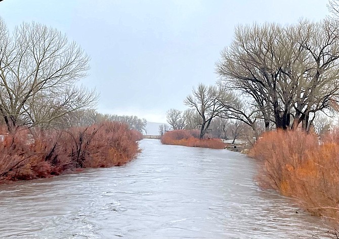
The Carson River is creeping up toward Willow Bend as it rises from rain and snowmelt. Tara Addeo photo
Less than 12 hours after the Carson River near Willow Bend subsided, forecasters issued a flood watch for the upcoming New Year’s weekend.
The watch starts 7 a.m. Friday as another warm atmospheric river arrives in Western Nevada and lasts until 4 a.m. Monday.
“Mainstem river flooding is most likely to occur on the East Fork of
the Carson near Gardnerville,” according to the statement. “Out-of-bank flows could result in road closures, causing travel impacts.”
On Tuesday night, the river’s crest arrived at Willow Bend just north of Genoa Lane prompting residents to prepare for flooding.
The river subsided without any serious flooding, but it was an indication of what the next storm could do.
“High snow levels and prolonged heavy rainfall will allow for significant rises on both mainstem and smaller rivers and streams,” according to a National Weather Service statement issued 9:30 a.m. today. “This may result in minor to moderate flooding on some area rivers and streams. Rock falls will be possible, especially in steep terrain and where soils are already saturated. Some urban flooding is likely, particularly in low-lying areas or poor drainage.”
Not helping matters is that Thursday is expected to see snow down to lower elevations with 2-4 inches at Lake level and up to 2 inches in the Western Nevada foothills.
Any snow that falls below 6,500 feet will likely join the rain in Valley drainages on Friday, causing increases in already saturated basins.
Forecasters urged residents living near the river to take action should flooding occur.
PREVIOUS STORY
While river gauges are reading below flood stages, residents near Willow Bend just north of where the river crosses Genoa Lane are placing sandbags to keep the river at bay.
Warmish rain melted snowpack on Tuesday morning sending a wave down both forks of the Carson River.
Gauges located at Woodfords on the West Fork and below the old Power Dam on the East Fork showed the river cresting well short of even the action stage.
The East Fork crested at 12.28 feet entering Carson Valley at 11:15 a.m. The West Fork at Woodfords hit 10.18 feet at 10:45 a.m.
But residents just south of where the two forks meet are in a particularly low spot and often end up with flooding before the rest of Carson Valley.
The next gauge is located in Carson City where the river passes south of prison hill. As of 7 p.m., the gauge was reading 4.82 feet and was expected to crest at 5.5 feet by midnight.
With another atmospheric river in the forecast, residents along low-lying regions should anticipate high water again on New Year’s Eve.
“The next storms will lead to additional rises in rivers and streams,” said Senior Service Hydrologist Tim Bardsley. “Rivers and streams may respond more quickly than they did today due to the priming nature of today's and last night's rain. Expect additional flood impacts in urban and poor drainage areas similar to, or somewhat worse than those experienced today.”
The East Fork is predicted to hit the action stage of 13 feet 7 p.m. Saturday, which means Willow Bend should see high water arrive about midnight.
The West Fork is expected to crest at 11.4 feet for several hours starting around 2 p.m. Saturday.
The river is expected to crest just short of action stage in Carson City at 4 a.m. Sunday.
Bardsley said small streams and creeks will see major rises Friday, especially where drainages are below 6,500 feet.
“Currently no mainstem river flooding is anticipated but can't be entirely ruled out if the Thursday-Saturday storms come in wetter and warmer than currently expected.”

Comments
Use the comment form below to begin a discussion about this content.
Sign in to comment