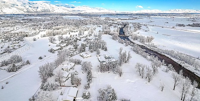
A drone shot of the Gardnerville Ranchos after the New Year's weekend snow storm.
JT Humphrey | Special to The R-C
A spot near East Valley Road in Gardnerville recorded almost as much snow as fell on Daggett Summit from a surprise New Year’s Eve snowstorm.
The location received 30 inches of snow, according to snow totals compiled by the National Weather Service, topping results for the greater Reno-Carson City-Minden area.
“The storm that brought significant snowfall on New Year's Eve does fit the pattern of a Tonopah Low,” National Weather Service Meteorologist Zach Tolby confirmed on Tuesday. “It's a pretty rare pattern. This is the first time I've actually seen it happen and I've been forecasting here for 11 years.”
Daggett Summit at the top of Kingsbury recorded 31 inches of snow, while Heavenly Ski Base reported 39 inches from the storm.
The Tonopah low storm brought 25 inches of snow to a spot in the Pine Nut Mountains, while the Ranchos itself received 22 inches. A Fish Springs resident reported receiving 23 inches of snow.
The storm tended to favor the eastern side of the Valley, which is opposite of typical conditions.
“It happens when we get a strong storm impacting the Sierra in just the right orientation that a surface low pressure forms in western Nevada around the area of Tonopah,” Tolby said. “As the surface pressure deepens it creates cyclonic (counter clockwise) flow which brings northeasterly surface flow to Western Nevada. This brings much colder surface air into the region from the north lowering snow levels much below what they would have been otherwise.”
The Pine Nuts were early to get big fat flakes as a blast of cold air turned rain to snow around 9:15 a.m. Saturday on Simee Dimeh Summit.
Fredericksburg resident Jeff Garvin recorded 14 inches of snow. A spot two miles north of Genoa recorded 13 inches.
Residents reported 10 inches of snow in Minden.
That snow arrived in the nick of time to head off serious flooding across the Valley.
The Carson River was still up to the gunnels on Sunday afternoon where it passes under Genoa Lane, but it was open.
Tracking the river through this storm has been a challenge, especially with the sudden shift from rain to snow that occurred on Saturday afternoon.
A flood graph downloaded at 6:30 a.m. from the National Weather Service’s Advanced Hydrologic Prediction Services site showed the West Fork of the Carson River at Woodfords cresting at 15.77 feet minutes after the arrival of 2023. That would exceed the record 15.4 feet.
However, whatever was jamming the gauge was cleared by Sunday afternoon and it showed a crest of 14.18 feet, short of the moderate flood stage. The last reading of 11.48 feet was recorded at 3:05 a.m. as the river was receding.
On the East Fork near Markleeville Creek, the river crested short of minor flood stage at 8.63 feet around 8 a.m. Saturday. Around 12:15 p.m. Saturday the gauge indicated 7.42 feet before going out until 5:05 a.m. Sunday. By Sunday afternoon, the gauge indicated 4.7 feet.
A similar outage affected the gauge near Horseshoe Bend which indicated a crest of 14.58 feet at 10:30 a.m. before steadily declining.
As of 2 p.m. Sunday it was reading 11.35 feet.

Comments
Use the comment form below to begin a discussion about this content.
Sign in to comment