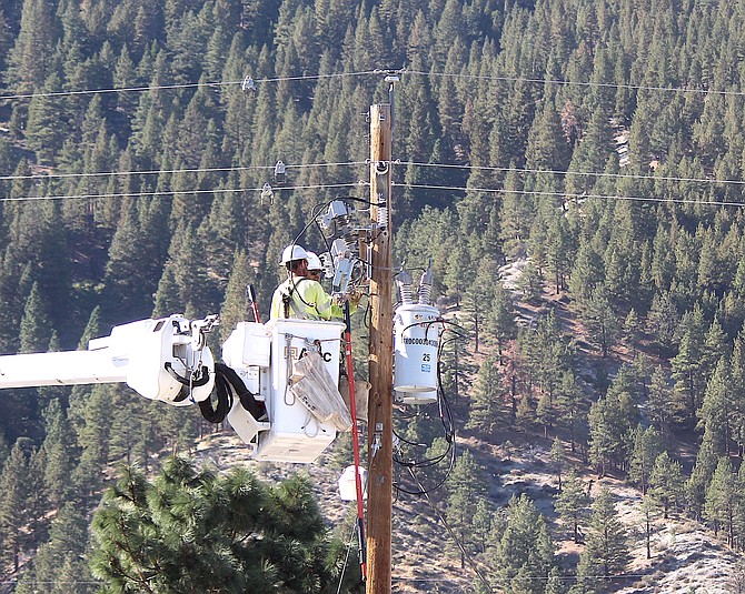
NV Energy contractors work on a pole in Genoa on Oct. 15.
Photo by Kurt Hildebrand.
Saturday Update:
Power is expected to be restored at 3 p.m. today after a public safety outage was implemented 2:13 a.m. today for ridgeline areas in the Spooner and Clear Creek areas.
NV Energy reported 76 customers above Glenbrook and 14 customers near Clear Creek, along with one near Mt. Rose have been affected by the outages.
High wind gusts over the ridgeline prompted the power company to shut off the electricity.
Other regions that were under a public safety outage watch have been canceled.
A company spokeswoman said that everyone affected by the outage has been notified and will receive updates on its status.
A Customer Resource Center was opened during the outage event until 6 p.m. or when power is restored at Whittell High School in Zephyr Cove, according to nvenergy.com/psom
A fire weather watch expired at 8 a.m. today but forecasters say the weather will continue to be breezy through the day as a front arrives.
Gusty winds blew through Carson Valley on Saturday morning with Centerville reporting a 49 mph gust at 10:10 a.m. with sustained winds of 25-30 mph for two hours before.
Minden-Tahoe Airports automated weather system reported a gust of 41 mph at 7:35 a.m.
Fish Springs residents had the top blast on this blustery morning with the fire station gauge reporting a 57 mph gust at 5:23 a.m.
A Nevada Department of Transportation gauge in south Gardnerville peaked at 42 mph at 1:52 a.m.
A brief rain shower left .08 inches of rain in Genoa around 9:45 a.m.
Posted Friday evening
A public safety outage has been canceled for Genoa to Jacks Valley and Glenbrook at Lake Tahoe.
The outage is still possible at Kingsbury and other spots along Lake Tahoe as ridge gusts are forecast to hit 80-100 mph tonight.
Just because the planned outage is canceled doesn’t guarantee high winds won’t knock out electricity near toppled trees.
NVEnergy.com reports 76 homes and businesses are without power this evening but should be restored before 6 p.m.
A fire weather watch takes effect 11 p.m. tonight with winds out of the southwest at 25-40 mph across the Sierra eastern slope.
However, the forecast for Minden has winds at 15-20 mph gusting to 30 mph.
Lighter winds in the Valley was one of the reasons the power company canceled the public safety outage.
Residents of Lake Tahoe and those living along the Carson Valley foothills, including Genoa and Jacks Valley, should be prepared for the possibility that high winds will lead to a power outage on Friday night.
NV Energy issued a public safety outage watch that says the outage could occur between 9 p.m. and 1 a.m. with it ending at around 3 p.m. due to high winds in the forecast.
The alert was issued at 12:32 p.m. Thursday.
A fire weather watch has been issued by the National Weather Service starting 11 p.m. Friday and lasting until 8 a.m. Saturday.
Winds are forecast to gust to 40 mph, with sustained winds around 25 mph in Carson Valley as a strong cold front arrives in Western Nevada.
More concerning for Kingsbury residents are possible strong ridgetop winds of 80-100 mph that could knock trees into power lines.
Strong winds of around 50 mph plus are expected to spread into the Western Nevada foothills, dropping to 25-40 mph as the day progresses.
Public safety outages are designed to prevent power infrastructure from causing fires during the fire weather watch that will see low humidity.
“Strong winds of this magnitude can cause fire to rapidly grow in size and intensity before first responders can contain them,” forecasters said. “Avoid outdoor activities that can cause a spark near dry vegetation, such as yard work, target shooting, or campfires.”
On the other side of the front, temperatures are expected to drop 15-25 degrees on Saturday with widespread freezes across Western Nevada.
The Weather Service has issued a freeze watch for Saturday night through Sunday morning with lows forecast to hit 21 degrees on Sunday night.
Rain and snow is forecast for Saturday with the possibility of Lake effect snows downwind from Lake Tahoe, especially after the recent warm temperatures. Around a fifth of an inch of rain is expected to fall on Saturday in Minden. There’s a possibility of 2-5 inches of snow falling above 7,000 feet, which will affect the passes on Sunday night.

Comments
Use the comment form below to begin a discussion about this content.
Sign in to comment