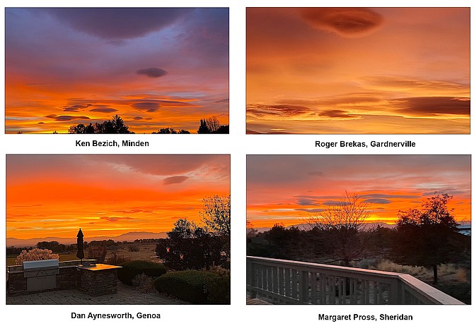
Just a sampling of the photos The R-C received of this morning's sunrise from across Carson Valley.
A red sky this morning may have been a warning to sailors of impending weather but it was catnip for Carson Valley sky watchers.
At least a half dozen photographs arrived in The R-C's email box before 8 a.m.
Today is forecast to be a bit cloudy but warm with a high temperature of 73 degrees as a system passes north of Western Nevada, according to National Weather Service Meteorologist Mark Deutschendorf.
The Valley will see some southwest breezes at 10-15 mph this afternoon, gusting to as high as 20 mph tonight.
It will be late Sunday night before the promise of Saturday morning’s red sky generates any precipitation.
“From Interstate 80 southward, measurable rainfall is unlikely through Sunday afternoon,” Deutschendorf said. “This front will bring additional winds to Sierra ridges tonight through Sunday night, with gusts of 80-plus mph at times.”
Lower elevations could see 30-40 mph gusts starting Sunday afternoon as the front arrives, affecting high-profile vehicles.
“Along with these winds, the temperatures will begin their downward trend Sunday, with highs dropping about 5-10 degrees from today, except areas south of Highway50 should squeeze out one more mild day before sharply cooler conditions come early next week,” Deutschendorf said.
A southerly shift in the jet stream could bring it right over Western Nevada, bringing peak wind gust speeds over the Sierra ridge of more than 100 mph early on Monday, with 35-45 mph gusts that afternoon in the valleys.
Lake Tahoe could see precipitation of between a quarter- and half-inch on Monday, with northern Mono County receiving around an inch near the crest.
Only around a tenth of an inch of rain is forecast for Minden, according to the National Weather Service.
“Sierra snow levels will drop to 7,000-7,500 feet by Monday afternoon, with a further drop to near 6,000 feet later Monday evening even though most of the precipitation will likely be ending,” Deutschendorf said. “Sierra passes above 7,000 feet could see slick conditions for the Monday evening commute, especially with the earlier sunsets with the time change back to Standard Time. Passes above 7,000 feet will see a 20-30 percent chance for 2 or more inches of snowfall.”
On the other side of the storm, cooler conditions will bring high temperatures down to the 50s with lows in the mid-20s.
“Another weather system may reach the Sierra and bring increased winds and chances for light rain and snow showers for the start of the Veterans' Day weekend,” Deutschendorf said. “However, the confidence is lower due to varied tracks for this system among the medium range ensemble guidance. This includes some scenarios that split this system and keep the Eastern Sierra and western Nevada dry.”

Comments
Use the comment form below to begin a discussion about this content.
Sign in to comment