A flood watch has been issued for the central Sierra through Monday evening due to thunderstorms.
The watch takes effect 1 p.m. today, according to the National Weather Service in Reno.
“Slow moving thunderstorms will produce areas of heavy rainfall with localized rainfall rates on the order of 1-1.5 inches per hour,” forecasters said. “Soils are already saturated with creeks, streams and rivers running full due to ongoing snowmelt. It will not take as much rain to cause excessive runoff.”
Saturday’s thunderstorms waited until just after the Carson Valley Days Parade to open up.
Fredericksburg resident Jeff Garvin reported receiving .44 inches of rain at a rate of just over 1.4 inches an hour with pea-sized hail.
Genoa received about a quarter inch, while a gauge at Sheridan Acres indicated 2.26 inches of rain.
Lightning strikes caused a power outage in Sunridge where a resident reported a small fire. While no fire was found, the storm moved north into Carson City, where it dumped 1.1 inches.
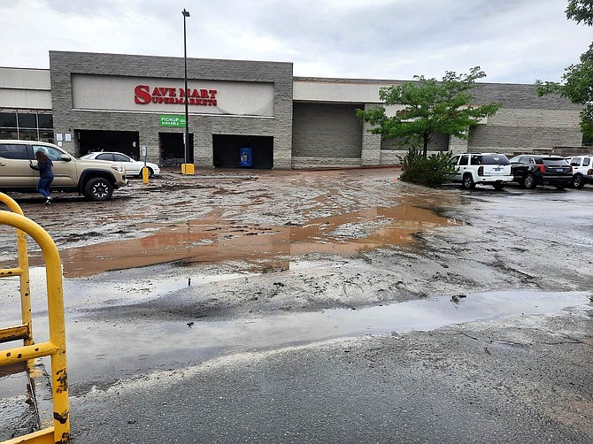
That storm resulted in a 1-2-foot mudslide in south Carson City around 3 p.m. Saturday. The Carson City Sheriff`s Office said the mud is up to 1-2 feet in some areas of the parking lot of the Galaxy Fandango Theaters on South Curry Street.
“The Galaxy Fandango Theater was closed so crews could conduct cleanup,” the Weather Service reported.
According to the Advanced Hydrologic Prediction Service, a river gauge on Eagle Creek peaked at 268 cubic feet per second at 5:30 p.m., up from the usual 15 cfs just 90 minutes earlier.
Slow thunderstorms can cause mudslides anywhere along the base of mountain ranges by dumping large amounts of rain in a short period of time.
In August 2022, slides washed out Highway 89 west of Markleeville and rendered a home above Carson Valley uninhabitable, burying it in 6 feet of mud and debris washed down from Horsethief Canyon.
Participants will get a first-hand view of the river on the Carson Water Subconservancy District’s “Get on the Bus!” two-day tour from Hope Valley to Lake Lahontan.
Videos and presentations will keep travelers informed between stops aboard the 55-passenger luxury bus.
The tour includes lunch as well as the chance for engineers, planners and floodplain managers to earn continuing education credits. Cost is $175 for both days, $100 for one day.
Go to https://www.cwsd.org/wp-content/uploads/2023/06/2023-GetOnTheBus-Final.pdf to see the full program.
While officials and residents have been preoccupied with flooding from snowmelt, thunderstorms can be just as devastating.
Eastern Carson Valley from Hot Springs Mountain south to Ruhenstroth experienced serious flash-flooding in the summers of 2014-15.
Both the Carson River’s east and west forks have mostly remained below flood stages for the last few weeks as snow continues to melt in the mountains.
The West Fork continues to bump around between the 12.5-foot action and 13.5 minor flooding stages, with a 13.3 foot rise forecast 5 a.m. Tuesday.
The East Fork at Horseshoe Bend is forecast to rise past the action stage of 13 feet to 13.2 feet 1 a.m. Tuesday.
While the river heights are similar, the amount of water they carry is significantly different. According to the Advanced Hydrologic Prediction Service, there was 2,840 cubic feet per second flowing in the East Fork at Horseshoe Bend, while the West Fork had 773 cubic feet per second.
The forks combine just south of Genoa Lane on their way downstream to Carson City. With the combined flow, a gauge just south of Prison Hill indicated 3,950 cubic feet per second on Sunday morning.

Comments
Use the comment form below to begin a discussion about this content.
Sign in to comment