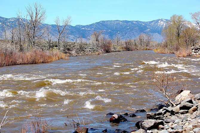
The Carson River just downstream from the Washoe bridge was actually at a lull around lunchtime on Thursday.
The closest thing to the betting line on the seasonal crest of the Carson River ranges from 4,000 to just over 13,000 cubic feet per second.
Every year, the Carson Water Subconservancy conducts a peak flow contest, where river watchers bet on when and how much water will go past the gauge south of Prison Hill in Carson City.
Even the most optimistic hydro-nosticator believes the river will reach its peak flow by Carson Valley Days and most of the guesses run below 9,000 cubic feet in the weeks after Memorial Day.
As of 4 p.m. Thursday, the river was at 3,050 cubic feet per second. By Monday night, it’s forecast to crest at 6,140 cubic feet per second at the Carson gauge, eliminating a half-dozen low guessers as it rises to 9.2 feet.
Betting the river’s peak flow is not an easy matter. Only two days ago, the Carson River at Horseshoe Bend was forecast to hit 14.3 feet by 5 a.m. Sunday thanks to snow melting at upper elevations. As of Saturday morning, that forecast has backed down to 13.5 feet, which would still be the highest the river has been this spring.
That segment of the river coming into Carson Valley crested at 12.86 feet 10:40 p.m. Friday.
The West Fork at Woodfords is forecast to crest at 13.4 feet or minor flood stage at 1 a.m. Sunday.
A flood watch is in effect across the Sierra Nevada through Monday morning.
“Latest deterministic forecasts from the River Forecast Center bring both the West and East Forks of the Carson River into minor flood stage by this weekend, with increasing flows down the Carson River as water routes downstream of the confluence,” National Weather Service Hydrologist Tim Bardsley said on Thursday afternoon.
“Minor flooding is also forecast for the West Fork of the Walker in Mono County and will continue along the East Fork of the Walker below Bridgeport Reservoir,” he said.
Forecasters are warning people to be cautious near the banks of creeks, streams and the rivers, which are all running high, cold and fast.
High flows typically occur late at night as low- and mid-elevation snow melts under temperatures that could reach 20 degrees above average.
But after this weekend, cooler temperatures return with conditions dropping below freezing in the mountains, which will help those bettors who think there’s more in store.
According to U.S. Natural Resources Conservation Service snow telemetry, the snow at Spratt Creek at the 6,063-foot level in Alpine County is gone, having dropped from 25 inches on March 10.
Carson Pass at 8,360 feet peaked at 68.3 inches of snow water equivalent on April 8 and dropped almost a foot to 57.6 inches on Thursday.
Snow water equivalent at Ebbetts Pass has been far more resilient, perhaps explaining the difficulty predicting how high the East Fork will rise this weekend. According to telemetry, the snowpack peaked at 76.6 inches on April 8 and has only fallen to 74.9 inches as of Saturday.
Douglas County is eligible for federal disaster assistance after the President declared a major disaster exists in Nevada on Friday morning and ordered federal aid to supplement State, tribal, and local recovery efforts.
The county and state declared emergencies as a result of the severe winter storms, flooding, landslides and mudslides March 8-19.
Federal disaster assistance is available to supplement state, tribal and local recovery efforts in Eureka, Lincoln, Lyon, Mineral and Storey counties, in addition to Douglas.
Federal funding is also available on a cost-sharing basis for hazard mitigation measures statewide.
The Nevada Department of Agriculture reported it has been working with the U.S. Department of Agriculture Farm Service Agency to find resources and assistance for farmers and ranchers affected by winter weather and flooding.
Producers should report loss of livestock or infrastructure to their local office to begin the process.
“We know it has been a tough winter and as the weather warms concerns are shifting from snow and cold temperatures to flooding,” said NDA Director J.J. Goicoechea. “We hope that this is the beginning of some relief for our farming and ranching communities.”
Any losses going forward should be reported within 30 days. Reports can be made via phone call, email, or by walking into a local office.
“Again, I want to emphasize our thanks to our agriculture industry for their dedication to their livestock and operations,” said Goicoechea.
The NDA has provided more information on disaster assistance available to producers on their website at agri.nv.gov. Find contact and location information for the nearest FSA office at farmers.gov/service-center-locator.

Comments
Use the comment form below to begin a discussion about this content.
Sign in to comment