This screen shot of lightningmaps.org shows strikes at 4:21 p.m. Friday.
At most a few drops of rain fell from a Friday night storm cell passing southwest of Douglas County bringing dozens of lightning strikes to the Sierra.
Lightningmaps.org indicated a single lightning strike in Douglas County just west of East Peak at 4:30 p.m. Friday from the storm that prompted a notice from the National Weather Service in Reno.
“The first round of showers and thunderstorms from Friday occurred mainly over Mineral, Mono and Alpine counties, with most
locations receiving .25 inches or less,” said National Weather Service Meteorologist Mark Deutschendorf on Saturday. “Low pressure meandering near the California coast will bring daily chances for showers and thunderstorms across the Sierra and Western Nevada. Thunderstorm potential will be highest south of Highway 50 through this weekend but may spread northward by Monday.”
It has been 50 days since the weather station in Minden, where records have been kept since 1906, has seen measurable rainfall.
August, July and September are typically the driest months of the year in Carson Valley. The exception was the record August 2022 with 2.8 inches of rain in Minden from several strong thunderstorms that also did significant flooding damage in Alpine County.
Seasonal precipitation outlooks issued by the Climate Prediction Center show Western Nevada shows even odds for wet weather through October, while higher chances that temperatures will be warmer over the next three months.
Previous Story
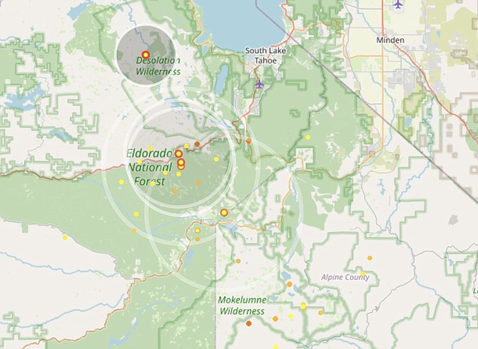
A strong thunderstorm traveling northwest along the Sierra Nevada is sending lightning strikes into Alpine and El Dorado counties.
The National Weather Service in Reno issued a 3:51 p.m. notice that the storm was moving near Carson Pass at 10 mph.
Lightningmaps.org indicates dozens of strikes in the Carson Iceberg, Mokelumne and Desolation wildernesses.
The thunderstorm is forecast to have wind gusts of 40 mph and up to half-inch hail.
“Gusty winds could knock down tree limbs and blow around unsecured objects,” forecasters said. “Minor hail damage to vegetation is possible.”
Another storm cell is traveling northwest this side of the Nevada state line with lightning strikes in Mineral County near Hawthorne and moving toward southern Lyon County.

Comments
Use the comment form below to begin a discussion about this content.
Sign in to comment