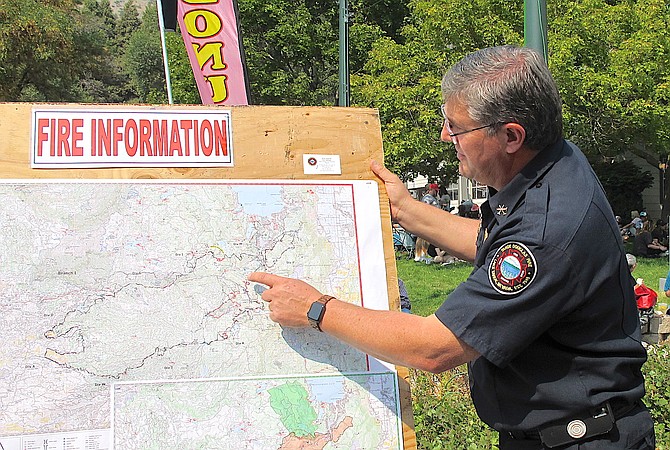
Tahoe-Douglas Fire Marshal Eric Guevin describes the Caldor Fire at the 2021 Candy Dance.
The Caldor Fire is continuing to creep east toward the Sierra crest north of Caples Lake.
The fire expanded 179 acres in the past 24 hours to reach 221,774 acres as 1,500 firefighters attempt to block it from burning further east toward Little Round Top. The fire edge is about a mile from the landmark that overlooks the Sierra Crest and Tahoe Rim trail junction located further to the east.
Firefighters are anticipating that southwest winds will increase today and Monday, which could cause the fire to jump containment lines along the eastern portion of the fire.
A red flag warning has been issued for 11 a.m. Monday to 5 a.m. Tuesday for the Sierra Front and most of Western Nevada.
Air quality dropped to levels that were unhealthy for sensitive group in Carson Valley on Saturday afternoon due to smoke from the Caldor and fires further south. Air conditions were moderate on Sunday morning.
A cold front is forecast to bring increasing winds today through Tuesday bringing increased fire concerns and colder temperatures.
Tuesday night temperatures are expected to drop to 31 degrees early Wednesday morning.
Previous Story
Firefighters working the Caldor Fire again find themselves racing a fire weather watch issued by the National Weather Service for Monday covering most of the Sierra eastern slope and into Western Nevada.
Forecasters are predicting 30-40 mph wind gusts from noon to 10 p.m.
As Monday nears, forecasters will refine their predictions which could result in the watch becoming a red flag warning for critical fire danger at some point over the weekend.
The fire continues to consume green areas within its perimeter generating smoke that’s forecast in Carson Valley through the weekend. The fire grew to 221,595 acres and remains 76 percent contained. Full containment has been delayed from Monday to Oct. 16. "This thing is not out there's a lot of potential left in this fire," a fire official said on Saturday morning. "Priority No. 1 is still going to be Division Quebec (the region northwest of Caples Lake)."
Heat mapping from the U.S. Forest Service and NASA’s Fire Information for Resource Management System indicates around 1,500 acres burning in the region north of Kirkwood that firefighters have referred to as the “alligator’s mouth.”
Some of that is the result of counter burns designed to help reduce the chances the fire will advance to the Sierra crest at Little Round Top.
A firefighter was injured overnight while dodging a snag and falling into “heat.” The firefighter was treated and released, but fire crews heeded the warning and drew back for safety’s sake.
The fire is currently burning near Cherry Creek and Schneider Camp 4WD trail, which was widened to serve as a fire break.
The region is the No. 1 priority for firefighters who are trying to link ridges, rivers and roads with improved dozer line up to 1,000 feet wide.
On the fire’s northern front, there was also active fire indicated north of Highway 50 near Pyramid Peak in the Desolation Wilderness.

Comments
Use the comment form below to begin a discussion about this content.
Sign in to comment