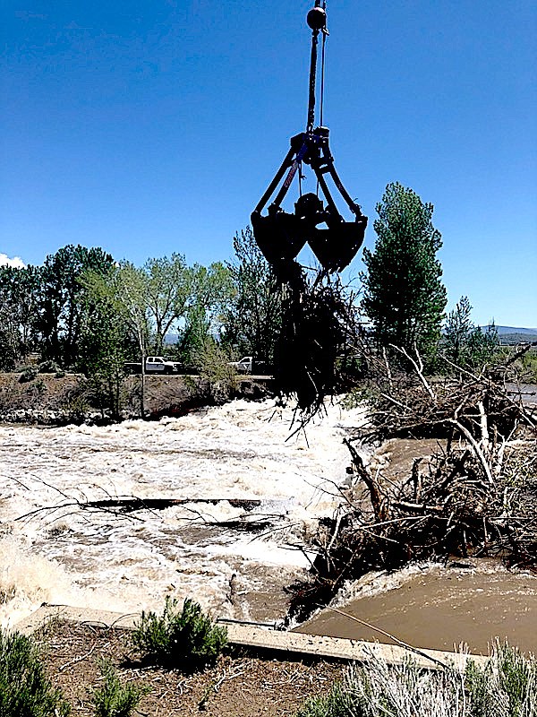
Logs and debris are lifted away from a logjam at the Virginia-Rocky Slough diversion on the East Fork of the Carson River by Connelly Crane.
Tod Carlini/East Fork Fire Protection District
High water on the Carson River’s East Fork took a big bite out of the levee that keeps the river from flooding the almost 100 homes next to Carson Valley Golf Course.
Douglas County commissioners are being asked to approve contributing $102,000 to rebuild the levee, with another $30,000 in contingency.
Commissioners meet 10 a.m. Thursday in the Douglas County Courthouse in Minden.
The total project is estimated to cost $260,000 with the Nevada Division of Water Resources contributing $65,000, the Carson Water Subconservancy coming up with $93,000, the Carson-Truckee Water Conservancy District making up the other $37,000.
Last spring’s flooding ate away a dozen feet of the levee, leaving 2-3 feet to keep the river in its channel. If the East Fork experiences even a fraction of last year’s high water, the levee could fail, according to the Carson Valley Conservation District.
Because the river is at its lowest point, officials say now is the best time to repair the levee, which is upstream from a diversion dam that saw blasting in May to remove debris.
Partnerships like those involved in the levee repair are critical to reducing potential damage in Carson Valley, Flood Control Manager Courtney Walker said at the dedication of a marker during Nevada Flood Awareness Week.
Douglas County, in partnership with The Nature Conservancy and the Army Corps of Engineers recently designed and installed the sign at the River Fork Ranch in Genoa.
The 800-acre ranch at the confluence of the east and west forks of the Carson River is critical to reducing potential damage downstream, according to Preserve Manager Lori Leonard.
Walker said she has been meeting with ranchers to learn more about the irrigation ditches that crisscross Carson Valley.
“We are working on a stormwater masterplan where we are prioritizing capital improvement projects, but we are also working with the agricultural community where we can partner with them for maintenance on irrigation ditches,” Walker said. “We learned a lot this past winter on how that whole system interacts as flood control and what we can do to really protect the community.”
Flood maps for the Carson River were released by the Federal Emergency Management Administration earlier this month.
Over the course of the more than seven years Walker has been in charge of the county’s flood management, she hasn’t seen it budge from Class 6.
The rating provides a 20-percent discount for homes in the Special Flood Hazard Area and a 10-percent discount for homes outside.
She said the score of 2,102 points is on the low end of the class, though the county has been active in working on flood plans.
A bump up to Class 5 would provide residents in the hazard area a 25 percent discount but wouldn’t do anything for everyone else.
At the present rate, residents save a combined $200,000 a year on their insurance.
The county just completed its five-year flood audit under the agency’s community rating system.
In her presentation on the audit, she showed county commissioners the sea of paperwork required as part of the audit. The county has to go through the audit every five years so residents in hazardous areas can buy flood insurance.
Having the flood plain mapped is a minimum requirement, Walker told the county, with 18 different activities that can earn the county points.
Those range from public outreach like Flood Awareness Week and the high-water mark at the River Fork Ranch. But they also include flood damage reduction and preparedness.
“It’s a pretty robust program and there is always a lot more you can go through,” she said.
The county also has maps and flood zone viewers where residents can look up their lot and find out if they’re in the flood plain.
“Many of the calls we get are people just calling and asking,” she said.
She said the county can get credit for remapping existing flood plains, that can occasionally result in removing residents from the hazard area.
Homeowners with a federally insured mortgage are required to buy flood insurance. Those outside of the flood plain may buy flood insurance, which contributes to the county’s score. Flood insurance only deals with structural damage to homes, not landscaping.
“If the county acquires a building and removes it from the flood plain, it gets a lot of points,” she said. “But that’s a very expensive option.”
There is a big difference between the flooding on paper and that which actually occurs.
Walker said mapping mostly focuses on the areas near the Valley’s waterways, as opposed to the alluvial fans at the base of the mountains.
“There is more alluvial fan flooding, and those maps are not as robust, and those channels tend to move,” she said.
Examples of alluvial fan flooding include the Johnson Lane floods during the summers of 2014 and 2015, and the flood in Horse Thief Canyon in August 2022 that partially buried a home.
“Storm water management is a critical issue for our community,” County Manager Jenifer Davidson said. “I’m pleased with the work by Ms. Walker and her team.”
Davidson said that the $1 million the county budgets annually for the department hasn’t changed in five years.

Comments
Use the comment form below to begin a discussion about this content.
Sign in to comment