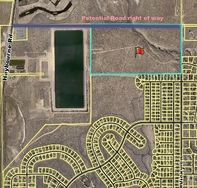
A map of the Warm Springs project including a proposed road to Heybourne along its northern edge.
A subdivision map and planned development for 80 acres between Saratoga Springs and the North Valley Wastewater Treatment Plant was approved 4-1 by county commissioners on Thursday.
The lone vote against the Warm Springs project was Commission Chairman Mark Gardner who raised questions about access after more than a dozen neighbors spoke against the project.
Commissioners included a condition that a second east-west road to Heybourne Road be constructed by the developer across property owned by the county. There is an unimproved dirt road running along the property line. The parcel to the north is in a conservation easement and the sewer pond runs close to the northern boundary.
Developers plan to build 80 homes on the property, which is zoned one-acre single family residential.
However, the geographic constraints on the property which is crossed by one of the north Valley arroyos, requires that the homes be clustered.
Under the county’s planned development rules, the developer must set aside at least 25 percent of the property as open space. That will provide a buffer for the wash and another for the sewer plant pond that is on the west side of the property.
But it will also reduce the size of the individual lots.
The property is owned by Bently Family Limited Partnership and consists of 80 parcels with the smallest at 21.780 square feet.
At least a dozen residents of Saratoga Springs turned at the commission meeting to raise a variety of issues, including traffic, noise and the odor from the sewer plant.
There’s a 12-acre parcel reserved for either side of the stream.
The developer has a decade to complete the four phases, with 19 single-family homes and two common spaces in the first phase, which is expected to be recorded by 2027.
Bordering on the wastewater treatment plant pond, the project required a dam breach analysis for the eastern embankment.
An open space buffer along the west side of the site to deal with the effects of the breach has been included should the dam collapse.
Planning commissioners recommended approval of the project 5-2 at their Oct. 10 meeting.

Comments
Use the comment form below to begin a discussion about this content.
Sign in to comment