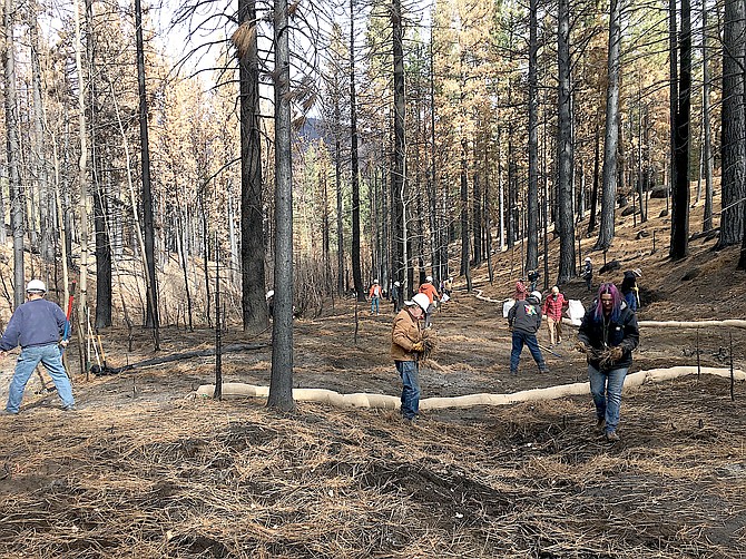
Volunteers seed the Musser and Jarvis drainage after the devastating Tamarack Fire burned through. Photo by Kimra McAfee
Dozens of volunteers spent the weekend before Thanksgiving working to help restore parts of the Musser and Jarvis drainage after the devastating Tamarack Fire.
They raked and spread seed in rough conditions and chinked in soil behind logs felled for erosion control CalFIRE California Conservation Corps crews.
Markleeville Water Company President Mary Young and husband Bill were among the volunteers, according to Alpine Watershed Group Director Kimra McAfee.
The inlet for the water company is downstream from where the work was conducted, McAfee said.
“The Musser and Jarvis drainage supplies 70 percent of Markleeville's water and was severely burned in the Tamarack Fire,” McAfee said.
The Alpine County Chamber of Commerce Tamarack Fire Assistance GoFundMe drive provided $5,000 for the native grass seed and wattles installed Nov. 19.
“All of the work done was approved by the U.S. Forest Service, as all of the land worked on is Humboldt-Toiyabe National Forest land.”
Markleeville Water Company's workday partners included Alpine Watershed Group, Alpine Trails Association, and Friends of Hope Valley.
Started by lightning and first reported on July 4, the Tamarack Fire smoldered in the Sierra for a dozen days before exploding into flame on July 16. Two-thirds of the population of Alpine County was evacuated ahead of the fire which swept down Pleasant Valley menacing Markleeville and Woodfords.
The fire moved so fast that in two days, it burned over the former incident command at Turtle Rock Park and resulted in moving the evacuation center from Woodfords to Gardnerville.
By July 18, the fire was approaching 20,000 acres in size, with no containment and two days of critical fire danger forecast. Only 517 firefighters were trying to keep the fire from spreading further north of Highway 88, which could have resulted in it burning into the Carson Range and into Carson Valley near Fredericksburg.
While that effort was successful, the fire burned southeast toward southern Douglas County and was visible in the mountains just west of Highway 395 at 5:30 p.m. July 21. The highway closed and the next day a spot fire began east of the highway in the Pine Nuts as it burned south toward Holbrook Junction, prompting Douglas County commissioners to declare an emergency for the first time during the summer. By the time the fire was brought to heel, it had consumed 14,873 acres in Nevada and 53,823 acres in California, and destroyed 25 homes between the two counties.

Comments
Use the comment form below to begin a discussion about this content.
Sign in to comment