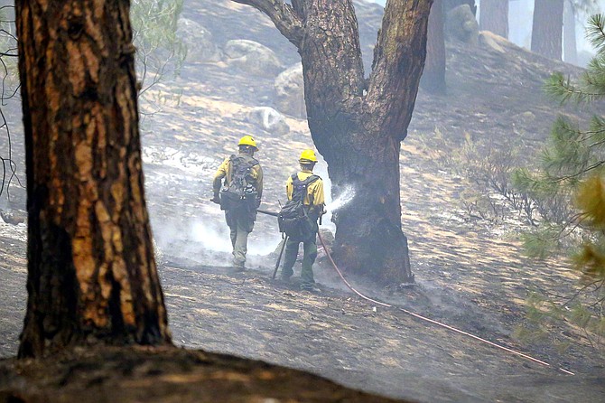
Firefighters douse hotspots on the Tamarack Fire burning in Alpine County. U.S. Forest Service Photo
Residents located in the area evacuated due to the Tamarack fire are being escorted to their homes this evening.
The Alpine County and El Dorado County sheriff’s offices are conducting the escorts for residents to secure their pets, papers and emergency items.
“Additional escorts on future dates will be determined by fire activity,” officials said on Monday afternoon.
The Carson Valley Community Food Closet is extending its services to anyone in need due to the Tamarack Fire.
Food can be accessed 12:30-4 p.m. Monday, Tuesday, Wednesday and Friday. Anyone seeking information may call the closet at 775-782-3711 or email info@thefoodcloset.org
Fire officials have ordered a damage assessment team to work in the fire area to determine the number of structures that have been destroyed or damaged.
New evacuations were announced to include Blue Lakes Road and Mesa Vista due to the fire. Mesa Vista has been under a voluntary evacuation order since Saturday.
Evacuations are spreading in Alpine County, including Blue Lakes Road and Mesa Vista due to the Tamarack Fire.
Alpine County ordered the evacuation of Mesa Vista at 3:10 p.m., according to the Alpine County Sheriff’s Office.
Blue Lakes Road has been under an evacuation order since just before lunchtime.
Mesa Vista is located along Highway 88 just south of Fredericksburg, while Blue Lakes Road connects to 88 in Hope Valley.
Winds picked up as thunderstorms arrived in Carson Valley around 3:30 p.m. Monday. Lightning strikes were spotted in the Valley.
Smoke levels in Gardnerville continued in the unhealthy range on Monday from the Tamarack Fire burning in Alpine County.
The smoke was so thick that forest officials weren’t able to conduct a flight with infrared to determine the extent of the fire, officials said.
The Tamarack Fire doubled in size to 23,078 acres over the weekend, as nearly 800 firefighters have more than quadrupled the size of Eastern Alpine County.
according to the National Interagency Coordination Center incident management situation report issued 8:30 a.m. Monday.
Fire officials hope to have a line around the fire by July 31, as 18 hand crews and 62 engines work the blaze.
The cost to fight the fire is up to $879,000 this morning, due mainly to the grounding of firefighting aircraft by smoke over the weekend.
Firefighters are hoping showers and increased humidity will help slow down the fire this afternoon, which remains at zero percent containment.
Firefighters plan to build lines along the northwest flank of the fire to prevent it from spreading north toward Highway 88 and Woodfords Canyon.
A red flag warning issued for Alpine and Douglas counties was canceled 3 a.m. Monday, after the threat of thunderstorms diminished.
While more thunderstorms are expected later this afternoon, they are expected to be wetter, possibly bringing much needed rain to the Tamarack Fire.
The Hawkins Peak fire camera shifted from night vision to day vision at 2 a.m. Monday, illuminated by the flames from the Tamarack Fire burning in Alpine County.
“This fire is not laying down at all,” Eastern Alpine Fire Department Administrator Terry Hughes told Alpine residents at a Sunday briefing. “I’ve been in the fire business for 46 years and I’m seeing fire activity I’ve never seen before.”
As of Sunday night, firefighters had managed to defend Markleeville and Woodfords from the worst of the blaze.
Alpine estimated the fire had grown to 25,000 acres, and said a half-dozen structures burned, all of which were on state property in the Shay Creek region of Alpine County.
Forest Service officials said they planned flights by an aircraft equipped with infrared cameras over the fire to obtain better information on the size and the extent of the blaze.
The Nevada Fire Maps page estimated the fire at 23,000 acres as of 1 a.m. As of the 9 p.m. update, the fire remained uncontained and burned through the night.
Firefighters have been focusing on protecting lives and property after securing the area around Markleeville and mopping up any hot spots.
Smoke from the fire continued to bring unhealthy air quality levels to Carson Valley with 233 air quality index at 3 a.m. Unlike Saturday, when afternoon winds helped to ease the smoke levels, Sunday saw increased smoke through the day.
The smoke also hampered the use of aircraft on the fire with visibility dropping to 1.5 miles at 7:35 p.m. A wind shift increased visibility for about an hour around 8 p.m. but conditions deteriorated again with visibility at 3 miles at 3:35 a.m.

Comments
Sign in to comment