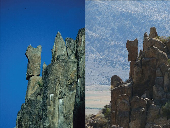
You'd think the barest breath of wind would be sufficient to knock this rock off the cliff, but it withstood a 6.0 magnitude earthquake in July 2021. The Antelope Valley rock was photographed in the 1990s by Jim Brune on the left, and the same rock photographed in 2022 by Daniel Trugman.
University of Nevada, Reno
A 6.0 earthquake shook a lot of rocks loose onto Highway 395 through Walker Canyon on July 8, 2021.
But for the University of Nevada, Reno, seismologists the mystery is why several large rocks balanced in precarious positions a few miles from the epicenter remained in place.
The earthquake occurred at 3:50 p.m. and there is video online of rocks falling all around a few cars in the canyon at that time. The quake shook bottles off the shelves at the Walker General Store, but most of the damage on both the highway and at the store was cleaned up by 5 p.m.
Seismologists think that the short duration of the earthquake wasn’t enough to shake loose several big boulders near Antelope Valley.
“Especially for these bigger precarious rocks, it’s not enough just to have a strong acceleration,” Daniel Trugman, a seismologist at the University of Nevada, Reno, said. “You have to have a long enough pulse duration to push it over."
The region along the eastern slope of the Sierra Nevada is known as the Walker Lane and is the site of frequent earthquakes, including a 1.7 magnitude quake at 8:45 a.m. Tuesday and a 1.9 5:23 p.m. Sunday in the mountains around 2 miles southwest of Walker, according to the Seismology Lab data.
The boulders, some of which stand at over 10 feet tall, have been balanced in their precarious positions since at least the late 1990s, when Jim Brune, a professor emeritus at the Nevada Seismological Laboratory, first took note of the rocks. Brune hypothesized that the rocks could be used to inform seismic hazard maps.
“If you see a precarious rock that is still standing, that gives you some upper bound on the ground motion that could have been observed at that site over the lifetime of the rock,” Trugman said. “Jim’s idea was to use these precarious rocks as a way to test hazard maps.”
The hazard maps are designed to predict where earthquakes might happen, so that engineers can design buildings that are safe enough to withstand the earthquakes that could strike a given region. Building an accurate hazard map is a challenge, though, because there are many variables that need to be taken into account, and there isn’t sufficient data to make accurate predictions. Researchers need thousands of years of data to make a useful estimate.
“Really the only hope you have is from the geologic record,” Trugman said.
That’s where the precariously balanced rocks become useful, and the rocks in Antelope Valley became particularly useful.
When the 2021 earthquake struck, Brune, who has been retired for years, asked Trugman to visit the precarious rock sites, where he was surprised to find that the rocks were still standing.
“But if you do the math, it makes sense,” Trugman said.
The earthquake was powerful, but because it was so close it had a short pulse duration at the precarious rock site.
“The latest engineering models developed for this problem predict that all the small rocks should be knocked down, and all the big ones, like the ones that are in all the classic photos, should be standing,” Trugman said. “And that’s roughly what we found.”
If precarious rocks are used to build hazard maps, it makes the development of the map more accurate. The rocks still standing in Antelope Valley validated the models that incorporate precarious rocks, but those models are much harder to build.
“It doesn't mean you can't use them, but it means you have to take into account both the strength of the ground motion and then also the pulse duration,” Trugman said. “And that's not something that's usually considered.”
The research findings make a compelling case for including precariously balanced rocks to build future seismic hazard maps. After seeing the large precarious rocks in Antelope Valley, Trugman wants to explore this idea more with rocks in the Truckee Meadows.
“This work has relevance for Reno in the sense that tectonically, the two locations are very similar,” Trugman said. “The Mount Rose fault system could produce an earthquake similar to the Antelope Valley event or bigger tomorrow, and it wouldn’t be that unexpected.”

Comments
Use the comment form below to begin a discussion about this content.
Sign in to comment