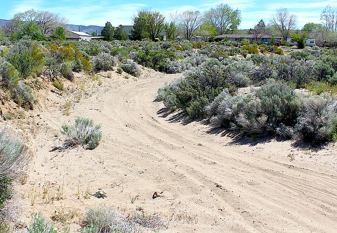
Buckbrush Wash looking east toward Fuller Avenue and the Pine Nut Mountains.
Photo by Kurt Hildebrand.
On July 20, 2014, angry dark clouds crawled over the Pine Nut Mountains heading northwest, loaded with monsoonal moisture.
Over two hours on that day, 1.23 inches of rain fell on Hot Springs Mountain sending a torrent of mud and debris into northern Johnson Lane.
A few weeks later, on Aug. 11, 2014, another 1.5 inches of precipitation fell in the Pine Nuts over 20 minutes, overwhelming what flooding infrastructure was in the neighborhood.
According to a preliminary environmental assessment issued by the Bureau of Land Management for new channels and basins, 146 parcels were damaged by floodwaters with $1.55 million in private and $927,205 in public property damage that summer.
That wasn’t the end of it, though. The following summer, flash flooding in the Johnson Lane area damaged 162 parcels and did $2.2 million in damage. During those summers of 2014 and 2015, it was a rare day that didn’t have a flash flooding alert blaring over Valley radios. Occasionally, there were several.
Nearly three dozen residents, many of whom experienced damage a second year in a row, filed a lawsuit in 2016 that was settled three years later. Part of that settlement was that the county would devote $830,000 to construction of the flood improvements being proposed in the draft. An environmental assessment is required because the improvements are largely on federal land.
On Friday, the comment period began for the preliminary assessment. Residents may comment on the assessment through June 11.
According to the draft, priority will be on constructing sediment basins near Romero and Stephanie, which were part of the settlement.
Additional basins will be built near Chowbuck and Skyline Ranch, according to maps available at https://go.usa.gov/xFgaJ
Second priority will go to the Hot Springs and Buckbrush Wash with four sediment basins, five channels and a drain located west of Fuller.
Areas located south of Johnson Lane are third in line for construction, according to the draft.
“This project will help mitigate major flooding events which have been occurring in this area for some time,” said Sierra Front Field Manager Kimberly Dow.
Not in the plan is a dam across Johnson Lane Wash that was estimated to cost $4.9 million four years ago.
The infrastructure was proposed in the Johnson Lane area drainage master plan that covers 27 square miles, 45 percent of which is private land.
There are twelve watercourses draining to the community that were analyzed in the plan.
“The area’s development planning was based on serial parcel maps which only required development to provide infrastructure similar to adjacent areas,” according to the documents. “Much of the Johnson Lane community was established without strict planning for stormwater conveyance.”

Comments
Use the comment form below to begin a discussion about this content.
Sign in to comment