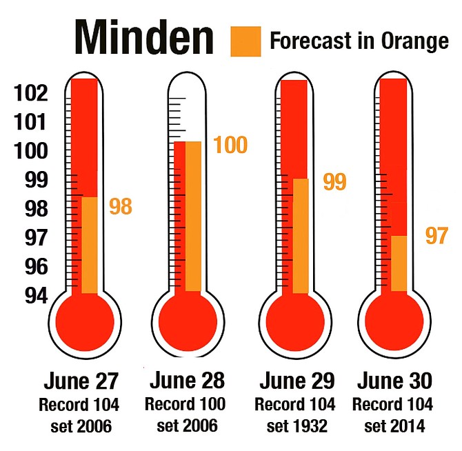
Forecast high temperatures in orange are only predicted to approach the record on Monday.
Photo by Kurt Hildebrand.
Four days of hot weather are expected in Carson Valley starting on Sunday.
Minden has already seen one 100-degree day in June and is forecast to see another on Monday, which would tie a record set in 2006.
A heat advisory has been issued for all of the east slope of the Sierra, with temperatures in the deserts expected to climb as high as 103 degrees.
So far June has seen an average maximum temperature of 88.5 degrees in Minden, only 1.5 degrees off the record of 90 degrees set in 2006. The previous 100-degree day was on June 18.
There may be some relief earlier should thunderstorms develop on Monday.
Forecasters advise residents to drink plenty of fluids, staying in air-conditioned rooms, stay out of the sun and to check on relatives and neighbors.
Children and pets should not be left unattended in vehicles.
“Take extra precautions if you work or spend time outside,” the advisory said. “When possible, reschedule strenuous activities to early morning or evening.”
Other tips include wearing lightweight and loose fitting clothing, schedule frequent rest breaks in shaded or air-conditioned environments.
Heat exhaustion symptoms include cold, pale clammy skin, and fast weak pulse, nausea, muscle cramps, weakness, dizziness and headache.
Heat stroke symptoms include a core body temperature of 104 degrees or more, an altered mental state, change in sweating, nausea, flushed skin, rapid breathing and racing heart rate.
If someone is suffering from heat stroke, get them somewhere cool and call 911, immediately.
The chance for thunderstorms will increase through next week, with most over Mono and Alpine County and the Sweetwaters Wednesday through Friday afternoons. By the July 4 weekend, most locations will have at least a slight chance of thunderstorms.

Comments
Use the comment form below to begin a discussion about this content.
Sign in to comment