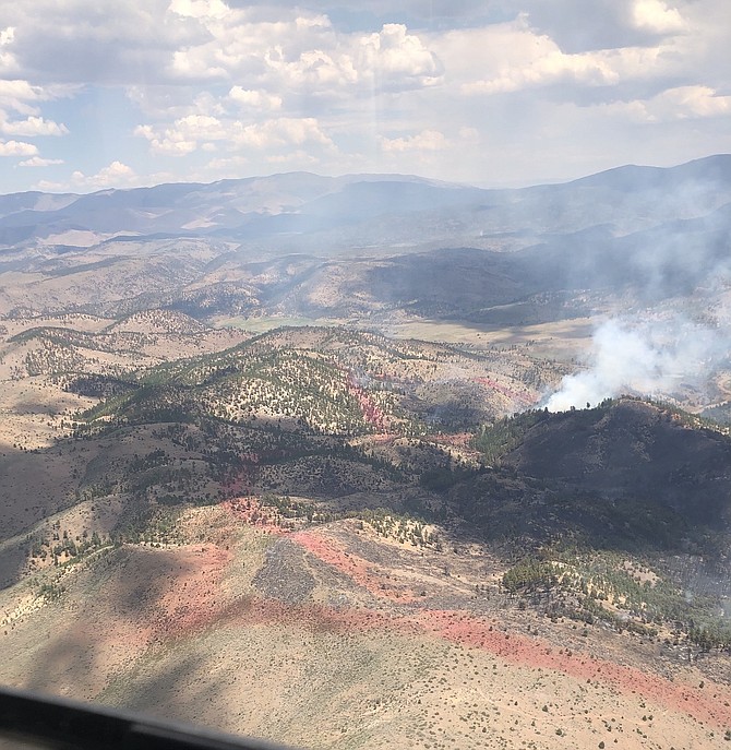
The East Fork Fire from the air on Sunday in this US Forest Service photo by Adrian Villegas
The smoke plume that dominated southeastern Carson Valley for the past four days was barely a wisp by Monday afternoon.
Firefighters are still working on the 1,136-acre, but most of their labors are indicated by how little smoke is rising above the hills south of Gardnerville.
Started by a June 30 electrical storm, the fire sprouted near Cottonwood Canyon just east of the East Fork of the Carson River.
The East Fork Fire was first reported around 3 p.m. July 1, and spread from 15 to 50 acres in the first five hours.
The Carson River didn’t pose much of an obstacle and the fire was burning on both sides by 8 p.m. July 1.
Thursday’s rainstorms slowed the fire down a little bit but wasn’t enough to help firefighters corral it.
Campers along the East Fork of the Carson River were evacuated on Thursday night.
Douglas County Sheriff’s Search and Rescue was called out to notify the campers in the area near the Horseshoe Bend hot springs in the Pine Nuts east of Carson Valley.
By Friday morning, acrid smoke that had been in the plume had drifted into the rest of Carson Valley, causing itchy eyes and bringing unhealthy air quality to the Nevada Department of Environmental Protection gauge at Ranchos Aspen Park.
Besides terrain, which is steep and rugged in that region, the canyon funneled heat and flames uphill into the canyon from the river bottom. By lunchtime Friday, the fire had increased to 200 acres in size and was spreading both east and west.
By 6 p.m. Friday, the fire had nearly tripled in size to 565 acres and five large and very large air tankers, and five helicopters were working with five hand crews to try and get a handle on the blaze.
Air tankers put in a retardant line to keep it from cresting the slope on the west flank of the fire, and into Diamond Valley where the Washoe Tribe’s Hung-A-Lel-Ti Woodfords Colony is located.
Around 250 firefighters were working to secure the eastern edge of the fire on Friday.
In addition to timber, fire officials said there were several old logs that contributed to the fire and smoke.
On Saturday afternoon, a storm cell passed over the fire, and outflow winds fanned the flames in all directions prompting fire officials to contact the Tribe and China Spring Youth Camp should the fire spread even faster.
While the retardant and handlines on the west side withstood the wind, the fire moved east up the Carson River corridor threatening the camp.
East Fork firefighters worked with camp officials to determine a point where they would have to evacuated, but rain overnight on Saturday kept the fire from spreading northeast.
Independence Day dawned with the fire at 1,100 acres and 30 percent contained.
The southeastern edge of the fire was still actively burning by the end of the day on the Fourth.
Firefighters were dealing with a large spot fire outside the containment lines and were strengthening the lines on the ground.
The fire closed Indian Creek Reservoir. The associated camping area was closed for maintenance work. Airport Road off Highway 89 was closed. The Alpine County Airport has been used as incident command for the fire.
The East Fork is closed to rafters, who have been ordered not to launch from Markleeville because the fire is burning on both sides for a long stretch of the river.
Fire officials hope to have the fire contained by Wednesday.

Comments
Use the comment form below to begin a discussion about this content.
Sign in to comment