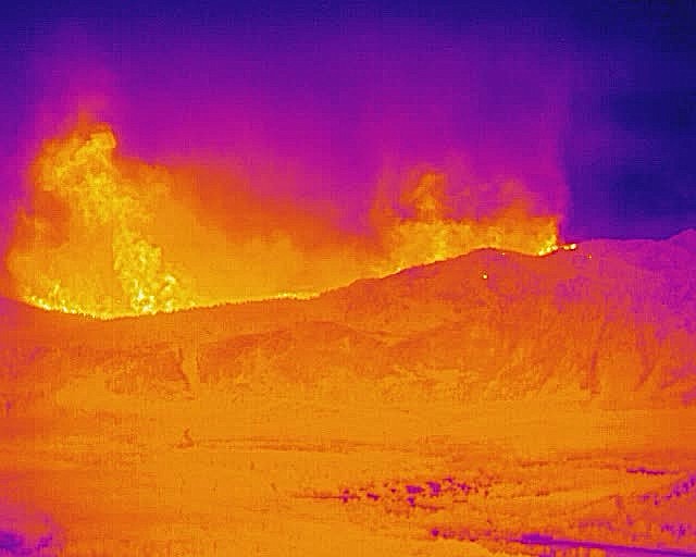
The ALERTWildfire thermal camera atop the Heavenly Mountain Resort at South Lake Tahoe, California allows the fire to be monitored through the heavy smoke and provides early identification of spot fires as seen The bright areas of the photo shows the height of the heat signature, not necessarily the height of the flames. The photo shows the view on Sunday evening, Aug. 29 looking to the west.
One of the two thermal cameras in place for the Caldor Fire shows active flames heading into the Lake Tahoe Basin with a dozen or more spot fires already established.
"The FLIR (forward-looking infrared) camera located on the tower on the top of Heavenly Ski Resort allows the fire to be monitored through the heavy smoke and provides early identification of spot fires, helping firefighters to respond appropriately," Graham Kent, director of the Nevada Seismological Lab and University of Nevada, Reno lead of the ALERTWildfire program said.
Live YouTube at WeatherNode shows the view of the fire from the thermal camera.
Evacuations are now underway in parts of the South Lake Tahoe area
"With only zero to quarter-mile visibility from the thick smoke, firefighters can't get close to the fire with aircraft and can't follow the progress of the fire to mount an attack," Kent, said. "These two cameras should give a good view through the smoke for fire managers. It's important to identify early any spot fires that jump ahead of the main fire or the fire front as it changes direction."
ALERTWildfire crews from the Nevada Seismological Laboratory and DigitalPath, a wireless Internet service provider based in Chico, California, installed the second camera Friday, Aug. 27 at Angel’s Roost at the top of the Heavenly Mountain Resort overlooking the Lake Tahoe Basin and the Sierra Nevada to the west.
The technicians installed the forward-looking infrared Teledyne camera at Angel’s Roost Friday with the immediate goal of providing high resolution imagery of active flames and spotting through thick smoke as the Caldor Fire spills into Lake Tahoe Basin.
With unprecedented fire conditions and smoke creating extremely low visibility and hazard to health, the 156,000+ acre Caldor Fire is 19% contained and has caused more than 40,000 people to be evacuated with evacuation orders just entering the Tahoe Basin.
The thermal camera data are on the ALERTWildfire camera page and are available to firefighters and the public to observe fire behavior. Nevada Seismo Lab technical staff integrated the Teledyne camera data into the ALERTWildfire real-time website and streaming at DigitalPath's weathernode.net site. The other thermal camera in place for the Caldor Fire is located on the Mt. Danaher ALERTWildfire site between Placerville, California and Pollock Pines, California near Highway 50. Both cameras are on loan from Teledyne for wildfire response.
The thermal cameras augment the dozens of ALERTWildfire cameras that view the Tahoe area and the western slope of the Sierra foothills that U.S. Forest Service, CalFire, PG&E and other agencies are using during the Caldor Fire. They operate 24/7 with near infrared capabilities at night.
ALERTWildfire is a network of over 900 specialized camera installations in California, Nevada, Idaho and Oregon used by first responders and volunteers to detect and monitor wildfires. Many of the cameras operate Nevada Seismological Lab's private digital microwave communication network. The cameras also support critical evacuation and firefighting efforts by relaying real-time information when it’s needed most.
ALERTWildfire is a collaboration between three major universities: University of Nevada, Reno; University of Oregon; and University of California, San Diego. First responders and federal, state and local agencies use the strategically placed cameras 24/7 to protect people, homes and the environment. Tahoe Prosperity Center has been instrumental in finding funding for the cameras in and around the Lake Tahoe Basin.

Comments
Use the comment form below to begin a discussion about this content.
Sign in to comment