Flood maps have been published to the Douglas County web site at www.douglascountynv.gov Scroll down to News and Announcements and click on the FEMA maps title.
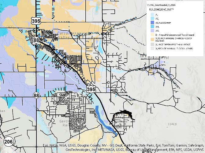
A revised flood insurance rate map and study have been published for review by Douglas County residents living in the Carson River floodplain.
The Federal Emergency Management Agency has announced that preliminary copies are available for public viewing on FEMA's website.
“This information is important to Douglas County residents because it may affect your flood insurance,” county spokesman Eric Cachinero said on Thursday. “Community members who believe their property rights will be adversely affected by the proposed flood hazard determinations may submit an appeal during the 90-day appeal period, which ends on July 10.”
The proposed flood hazard information includes additions or modifications to Special Flood Hazard Areas, base flood elevations or depths, zone designations, and regulatory floodways. This information will serve as the basis for floodplain management measures that the community must adopt to qualify for participation in the National Flood Insurance Program.
To see if your property may be affected visit https://douglasnvgis.maps.arcgis.com/apps/webappviewer/index.html?id=931ae1d5726c4e369c66063a46d888da
Firefox or Chrome browsers are supported. Safari is not.
Appeals must be supported by scientific or technical data and submitted to FEMA. The agency will consider all appeals and comments before making a final determination at the end of the 90-day period.
If no appeal is submitted by the community within 90 days, FEMA will consolidate and review any individual appeals or comments received during this time. The agency will then make any necessary modifications to the proposed flood hazard information before issuing a Letter of Final Determination.
For more information about these proposed flood hazard determinations, community members can call FEMA's Mapping and Insurance eXchange (FMIX) at 1-877-FEMA-MAP (1-877-336-2627) or email FEMAFMIX@fema.dhs.gov.
“Douglas County encourages all community members to review the proposed flood hazard information and submit any appeals or comments before the 90-day period ends,” Cachinero said. “The safety and protection of our community is our top priority, and we are committed to working with FEMA to ensure that our floodplain management measures are accurate and effective.”
Douglas County has created a webpage to help residents navigate this process: https://douglas-county-nv.civilspace.io/en/projects/federal-emergency-management-agency-flood-maps
Visit fema.gov/flood-insurance or www.fema.gov/press-release/20240416/fema-updates-flood-maps-douglas-county for more information.

Comments
Use the comment form below to begin a discussion about this content.
Sign in to comment