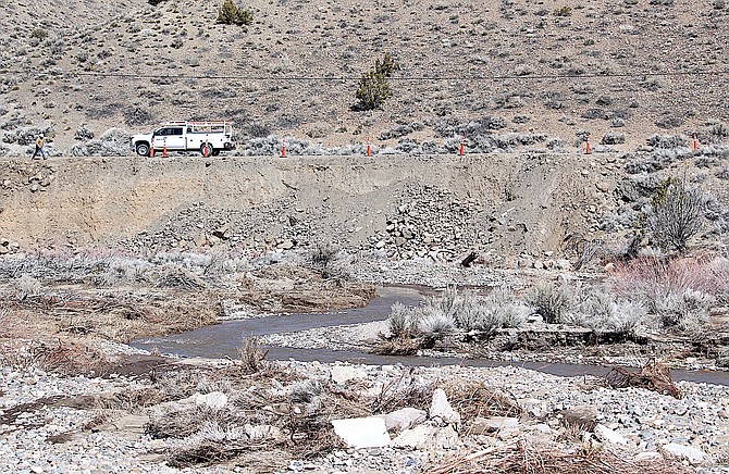
A work truck on Fish Springs Road above where Pine Nut Creek undermined the bank during flooding earlier this month.
Photo by Kurt Hildebrand.
With snowmelt still feeding it, Pine Nut Creek continues to flow through Fish Springs even as workers try to repair some of the damage from recent flooding.
There’s still plenty of snow in the Pine Nuts and multiple fires over the years have reduced vegetation that might slow down the runoff.
Both Pine Nut and Buckeye creeks drain into Carson Valley and with heavy snow and rain this year, that has led to flooding across the East Valley.
A feasibility study is underway to determine a way to reduce flooding from Pine Nut Creek, which drains 55.5 square miles above the community of Fish Springs.
The creek and its tributaries carry around 7,474 cubic feet per second of water downstream of Jo Lane.
“When these flood flows reach the Allerman Canal, the flow spreads out across private residential and agricultural parcels,” according to a request for proposal on the study. “These flows flood Toler Lane at the future intersection with Muller Parkway.”
Three spots have been identified as potential flood control basins south of Fish Springs Road near the intersection with East Valley Road.
But those won’t be much help to Fish Springs, where residents are hoping to generate support for construction of a dam near East Jacobsen Lane where the creek passes through a narrow canyon before arriving on the other side.
County Engineer Jeremy Hutchings said the feasibility study should be done in a couple of months.
“I have a capital improvement project on the books for flood mitigation on the Pine Nut Creek,” Hutchings said. “The first step is a feasibility analysis to reduce the flood flows and one option we are looking at is a dam. It’s only at the feasibility stage at this time.”
Resident Mark Dieter said his place on Lupo Lane experiences flooding at least twice a year. Hutchings visited his home to look at the damage on March 16.
“He, my neighbors, and I discussed the proposed solutions,” Dieter said. “We agree that the most viable option that will protect the most people for the least cost is a dam at the East end of Jacobsen Lane.”
Dieter said he remembers the Aug. 6, 2014, flash flood that sent water raging down Pine Nut Creek in the middle of the night.
“It hit us with no warning,” he recalled. “No rain fell in Fish Springs, but 1.75 inches fell in 45 minutes in the Pine Nuts. It was right after the Bison fire so there was nothing to hold the water back.”
That flood sent mud and debris down the creek, which jumped its banks sending two feet of water over Fish Springs Road.
“I removed 80 cubic yards of mud from my yard,” Dieter said. “My garage door was pushed in, and debris was everywhere.”
Pine Nut Creek continues along Fish Springs Road to the Allerman Canal where the road turns to Toler Avenue.
That canal leads north to the Dangberg reservoir behind an actual dam that prompted concerns during the March 10-12 storm. The county issued a cautionary flood warning for around 50 homes downstream from the reservoir.
Meanwhile, on the southern tip of the reservoir, residents were dropping concrete barriers into the inlet in an effort to divert the flows from their homes, according to a broadcast news report.
The reservoir was the subject of a long discussion at the Feb. 6 Water Conveyance Committee after the flooding that occurred in January.
The ditch which passes by homes built around the reservoir used to connect to another Dangberg reservoir to the north that has since been decommissioned.
Resident Craig Parsons said a 4-foot culvert installed by homeowners worked until the Pine Nut fires.
“Now we’re getting inundated with more water than the ditch is designed for,” he said. “All we’ve been trying to do is figure out how to divide this water a little bit.”
Parson’s said the ditch has grown in the flooding.
“Every inch of water now that comes in that ditch from the Pine Nut that isn’t going past the roundabout into the south end, is going down that into the lake.”
The ditch hasn’t been used for irrigation purposes for 15-20 years, according to neighboring rancher Frank Godecke.
In 1979, when the Dangberg property sold, an easement was recorded that allows the ditch to be used for stormwater collection.
The ditch has been piped in places, and when it clogs, the water backs up causing flood concerns.
A diversion on the canal south of the pond controls flows between the upper and lower Allerman, according to Allerman Upper Virginia Irrigation Co. President Matt McKinney.
“Depending on what’s flowing into the Upper Allerman and Pine Nut Creek at times can bring a lot of water out,” he told the committee.
“In the recent event over New Year’s weekend, the Lower Allerman was 160 cubic feet per second,” McKinney said. “The reservoir is for irrigation. It’s considered a high hazard dam, and the outlet only allows 68 cubic feet per second. So, if we would allow and Mother Nature did allow more water to go into that reservoir than what it’s designed for, we’re putting that dam at risk and homeowners below the dam, Town of Minden, and a lot of people at a high level of risk in the floodway.”
Dams have been floated as solutions to Carson Valley flooding for decades, starting with a dam near Horseshoe Bend on the East Fork proposed at the beginning of the 20th Century. That dam was proposed to be 222 feet high, cost $1.3 million and back up 50,000 acre feet of water.
After decades, the Bodie Dam plan, which would have cost $117 million, finally died in 1989. A proposal to build a dam above Johnson Lane was proposed to cost $4.9 million in 2017.
A Fish Springs resident upstream of Dieter said he was opposed to having a dam.
“What happens when it bursts?” he asked.

Comments
Use the comment form below to begin a discussion about this content.
Sign in to comment