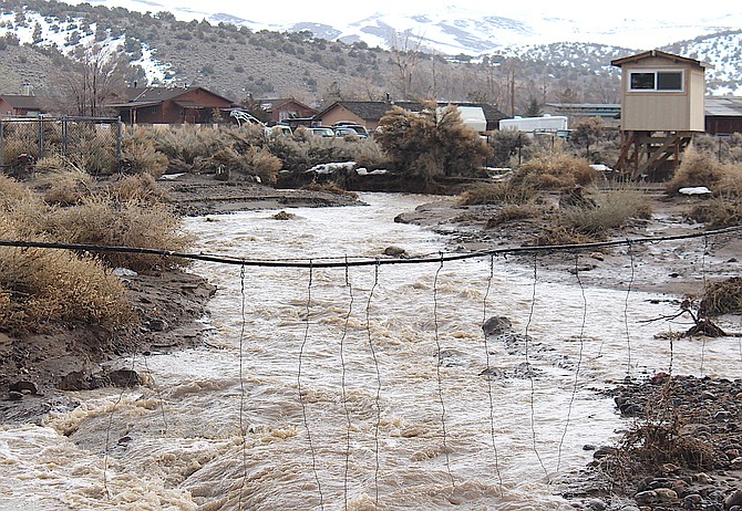
Smelter Creek flows on Saturday morning near where it crosses Mustang in Ruhenstroth.
Photo by Kurt Hildebrand.
Even as a flood advisory passed downstream, a new flood watch has been issued for 5 a.m. Tuesday through 11 p.m. Wednesday.
Rain showers this morning are expected to decrease this afternoon as a new front prepares to arrive on the coast tonight.
“Heavy rain with elevated snow levels are expected to renew the risk
of flooding Tuesday morning through Wednesday, mostly in areas below approximately 7,000 feet,” according to the National Weather Service in Reno. “Areas of primary concern are small creeks and streams, and areas with poor or obstructed drainage, including areas impacted by flooding recently. Mainstem river flooding is not currently forecast, but minor to moderate river flooding can not be ruled out especially in lower elevation basins, and in areas that experienced recent flooding.”
Previous story
A flood advisory for Western Nevada has been extended nine hours today as more rain is forecast to arrive this afternoon.
Rain fell overnight in Carson Valley with Minden reporting .92 inches, according to the National Weather Service.
Genoa and Gardnerville both recorded .8 inches overnight.
Less than a tenth of an inch of rain is forecast to fall in Minden over the rest of Sunday and into Monday morning.
Winds are expected to remain around 10 mph out of the south through the rest of the day.
Previous story
Snow, rain and even some sun rolled through Carson Valley on Saturday as a flood advisory continued in effect through Sunday morning.
“Urban and small stream flooding caused by rain and snowmelt is expected to continue through the evening and subside slowly through Sunday morning,” National Weather Service Reno Meteorologist Amanda Young said on Saturday afternoon. “Weaker short waves will … produce periods of light to moderate snowfall across the Sierra with some light rain showers sneaking into Western Nevada through Sunday morning. A somewhat stronger wave will bring better dynamic forcing and moisture into the region later Sunday morning into the afternoon.”
The flood advisory for Carson Valley has been extended to 8 p.m. Sunday.
“Snow levels have been gradually lifting above 6,500-7,000 feet this afternoon and early evening. Snow levels will for the most part make a slight downturn tonight and then settle mostly between 5,500-6,500 through Sunday.”
Heavenly Mountain Resort announced it will start around 11 a.m. Sunday, but may be earlier depending on how quickly they can prepare for guests.
The resort spent Saturday conducting avalanche control, which could be heard across the Valley.
The resort reported receiving another 10 inches of snow over Friday night.
“Heavier snowfall across the Sierra will accompany bands of convection that may even bring an increased threat of thunder across higher terrain as well,” Young said. “That being said, a couple more feet of accumulating snow will top the higher Sierra back- country areas above 7,000 feet with the Lake Tahoe Basin seeing about a 30-40 percent chance for up to 6-8 inches of new snow. Higher Sierra passes could see travel impacts overnight into Sunday morning for those more daring souls who desire to venture into the mountains.”

Comments
Use the comment form below to begin a discussion about this content.
Sign in to comment