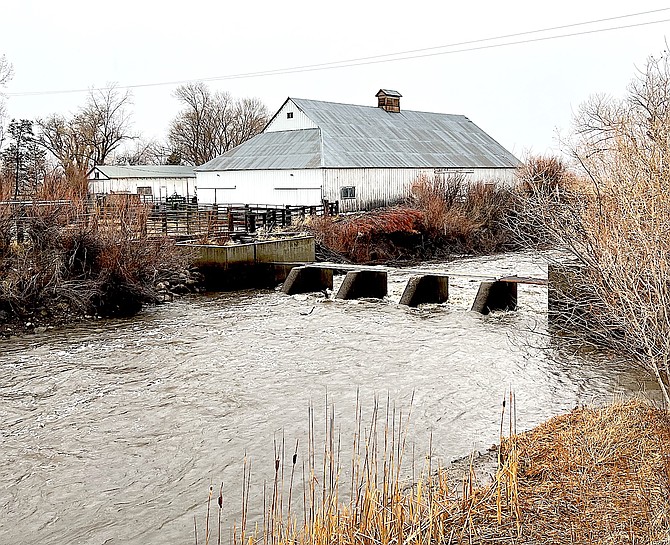
The Brockless Slough diversion structure located just east of Highway 88 was filled to the brim at 9 a.m. Dec. 31, 2022, about an hour before a Tonopah low turned the rain to snow.
Photo by Kurt Hildebrand.
There are lots of Carson Valley fields that have had snow on them since the beginning of the year.
Centerville resident and former Deputy Water Master Julian Larrouy said that he’s seen more intense storms than the ones that have pummeled Western Nevada over the past few months.
“In the early ‘50s, we had drifts that covered our pickup,” he said. “There were more intense storms then.”
However, this is the first time he’s seen this much snow for this long.
“I have never seen the ground covered with snow this long, ever,” he said. “That's 88 years worth.”
That could change in a big way on Friday when a warmer atmospheric river is forecast to arrive in Western Nevada, turning snowy fields to soup, depending on snow levels.
On Tuesday, Douglas County urged residents to prepare for possible flooding starting late this week, including road closures.
“While significant rises are expected on many main-stem rivers, our greatest concerns are currently creeks and streams draining large areas of terrain with shallow snowpacks below around 5,500 feet and urban poor drainage areas where deep snow may be restricting drainage,” Senior National Weather Service Hydrologist Tim Bardsley said on Tuesday.
The snowpack at mid and high elevations is expected to absorb the rain, those areas with only a few inches or feet will likely contribute to any flooding in the Valley on Friday.
“Keep an eye on the forecast, as any significant increases to expected precipitation and or rain-snow elevation would expand flooding concerns,” he said.
More snow is expected to arrive today with places in lower elevations seeing around 2 inches.
On Friday, all rain is expected in the Valley as an atmospheric river arrives, with another possibly following on Monday.
It has been nine weeks since a Tonopah low shifted a forecast New Year’s weekend rainstorm turned to heavy wet snow.
A train of cold storms followed bringing 57 inches of snow since Jan. 1, according to Minden Weather Watcher Stan Kapler.
Kapler reported receiving 5 inches of snow over last weekend’s storm, which brought blizzard conditions that closed Heavenly Ski Resort on Sunday and prompted a warning from Kirkwood.
Kapler has recorded 15.3 inches of precipitation since Oct. 1. The record for annual precipitation in Minden was set in 2017 when 20 inches fell during the calendar year.
Douglas released a list of county Sandbag locations which are ready to go. Residents must bring their own shovel.
ROOF SNOW LOAD
Click here for the County’s Flood Resource page, which includes the most up-to-date information.

Comments
Use the comment form below to begin a discussion about this content.
Sign in to comment