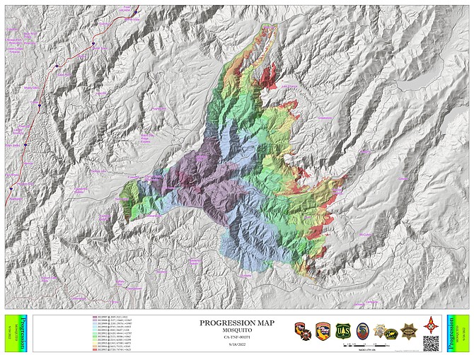
A map showing the progression of the Mosquito Fire was released on Sunday morning.
Cooler, wetter weather allowed firefighters to build a line around nearly 40 percent of the Mosquito Fire over the weekend as winds brought clear conditions to Carson Valley.
“Widespread rain over the fire area continues to reduce fire behavior, but warm, dry weather will return at the end of the week,” officials said on Monday morning. “Fire activity has slowed down, but the firefighters have not. While the rain presents a different set of challenges to the fire-suppression effort, crews continue to work, taking advantage of the lull in fire activity to secure the fire perimeter and increase containment before warm, dry weather returns.”
Light rain fell in Carson Valley on Monday morning and was expected to help cool down the fire burning 40 miles west of Minden, where the National Weather Service has issued a flash flood watch.
Most of the forecast 1-2 inches of rain is expected to fall over the next few days in the northern Sierra.
There’s even a possibility of snow above 9,000 feet through Wednesday.
Carson Valley is only expected to see about a third of an inch of rainf from the storm.
With rain showers forecast to continue over the fire today and becoming heavier tonight, fire crews are going to make as much progress as they can before the storm clears and warm conditions return.
“Firefighters will continue shoring up the corners of the fire and ensure the southern and western flanks hold along the communities,” officials said on Sunday. “Firefighters will also continue the process of backhauling unneeded hose, tools, and equipment from areas where they are no longer needed.”
Fire detection on the Federal Information for Resource Management site indicates the fire laid down overnight on the eastern front.
But it was a shift in the winds that brought clear air to Carson Valley on Saturday.
Fire.airnow.gov indicates air quality in the good range for much of Western Nevada and even areas directly downwind of the fire, like Alta, Calif., have seen an improvement.
Forecasters say the smoke today will be similar to Saturday for most of Western Nevada with the densest smoke in the Sierra Valley and Portola, blowing east into West Central Nevada overnight into Monday morning.
Winds that will give Carson Valley residents a break from the smoke today could complicate efforts to extinguish the Mosquito Fire burning in the Sierra.
As of 7 a.m. Saturday, firefighters increased containment by 1 percent to 21, while attempting to head off the 75,000-acre fire as it burns east along a 20-mile front.
The Mosquito fire is the largest fire burning in California having advanced nine miles since last week and is now burning 41 miles due west of Minden.
After a brief flare-up on the fire’s western flank was extinguished over the past two days, evacuation orders were lifted Friday afternoon for Georgetown, Calif., located on the far western flank.
“Overnight, firefighters continued patrolling and securing control lines in anticipation of increased gusty winds coming into the fire area today ahead of the advancing storm system,” according to fire officials. “Winds are forecasted to peak mid-afternoon with 20-25 mph gusts along the ridges. These winds will test containment lines and have the potential to spread embers and start spot fires ahead of the eastern flank.”
As much as an inch of rain is forecast to fall on the fire by Wednesday, which firefighters will use to make progress, but it won’t be enough to extinguish the blaze.
“While the rain will help moderate and slow the fire’s growth, it is not forecast to be a season-ending event,” officials said. “With the critically dry fuels and warmer weather back in the forecast for later next week, firefighters will use this weather system as an opportunity to make significant progress in containing the fire.”
The fire is burning in rough terrain around the North and Middle Forks of the American River. The southeast corner of the fire has reached the King Fire burn scar and is starting to slow down on its own.
A burn operation along the Middle Fork has been completed in preparation for the winds.
Forecasters predict smoky conditions in Western Nevada will improve later today as the storm system arrives on the coast.
Southerly winds will blow the smoke north and away from Western Nevada, with Sunday seeing improved conditions across the region.
On Friday, smoke hit hazardous levels in Carson Valley with an air quality index peaking at 441 around 7 p.m. in Minden.
The Tigers Homecoming game was postponed until Monday as a result of the smoke.
“Rain from earlier in the week should have a significant dampening effect on the Mosquito Fire and the resultant smoke,” Reno Meteorologist Wendell Hohmann said on Saturday morning. “So, we are anticipating a rather incredible first weekend of the fall season.”

Comments
Use the comment form below to begin a discussion about this content.
Sign in to comment