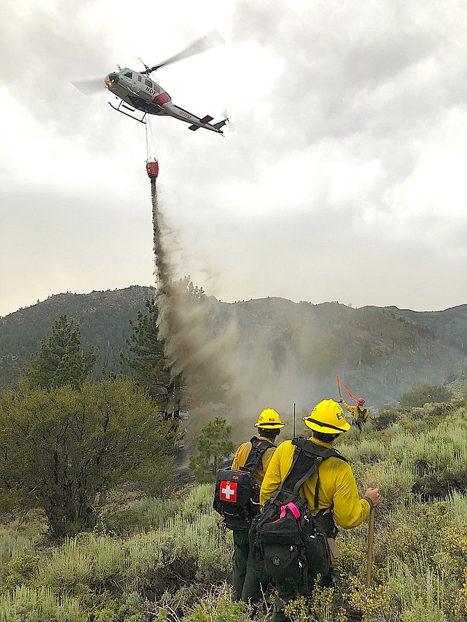
A helicopter dropping a bucket of water on the Swauger Fire as two firefighters look on. U.S. Forest Service photo
The fire was started by a lightning strike around 3 p.m. on Tuesday.
Carson Engine 316, an Eastern Sierra hand crew and a Nevada Department of Forestry helicopter are are working toward full containment.
A half-dozen smoke reports were received by the Bridgeport Ranger District, including two fires south of Topaz Lake near Risue Canyon. Both fires were under an acre in size and declared controlled as of 8 p.m.
The Swauger Fire is a quarter of an acre in size burning just east of Sonora Junction along Highway 395. It had been contained by a helicopter and fire engine on scene as of 7 p.m.
The Obsidian Fire, also south of Topaz Lake is under an acre in size and has been declared controlled and contained as of 5 p.m.
Firefighters were unable to locate the remaining two smoke reports, Leavitt and Spring Gulch. They will continue the search in the morning.
A significant thunderstorm passed over Mono, Alpine and Douglas counties on Tuesday afternoon.
East Fork firefighters responded to a fire on a utility pole at Cathy Lane in the Johnson Lane neighborhood around 7:15 p.m. The fire burned through the crossbar causing some arcing.
East Fork also responded to several reports of smoke in the Pine Nut Mountains east of Carson Valley.
Electricity was out in part of Carson Valley for the third day in a row, with 145 Gardnerville NV Energy customers without power from 6:20 to 8 p.m. Tuesday.
According to a statement issued by the National Weather Service at 7:50 p.m. Tuesday, thunderstorms will continue to develop over western Nevada and northeast California into the evening and possibly overnight.
“Strong outflow winds over 50 mph, small hail and brief periods of heavy rain may accompany the stronger thunderstorms,” forecasters said. “Lightning strikes may also trigger wildfires. Gusty outflow winds are producing localized areas of blowing dust across western Nevada. Blowing dust may limit visibility on area road, so be aware for rapidly changing conditions through this evening.”
Heavy rain in Mono County caused a mini-van to hydroplane off Highway 395 in the Walker River canyon and come to rest 30 feet down an embankment around 4:05 p.m., according to the California Highway Patrol.
Rain in Mono County on the Slink Burn prompted concerns that there might be a mud slide, similar to one that occurred across Highway 158 near Grant Lake south of Lee Vining.
Hot temperatures are expected to continue through 10 p.m. Wednesday with an excessive heat warning bringing triple digit temperatures. On Tuesday, the high temperature in Minden was 101 degrees, still well short of the 104-degree record set in 1932.
Expect a high temperature of 95 degrees on Wednesday. Temperatures are expected to hover in the mid-90s through the Fourth of July weekend.

Comments
Use the comment form below to begin a discussion about this content.
Sign in to comment