The Nevada Highway Patrol closed Interstate 580/U.S. 395 to trucks through Washoe Valley and the new stretch of 580 from Reno on Monday because of winds gusting to well over 50 mph.
There were NHP cruisers parked at the Mount Rose junction to make sure truckers didn’t ignore the warnings and another NHP SUV at the crest of Lakeview Hill for the same reason.
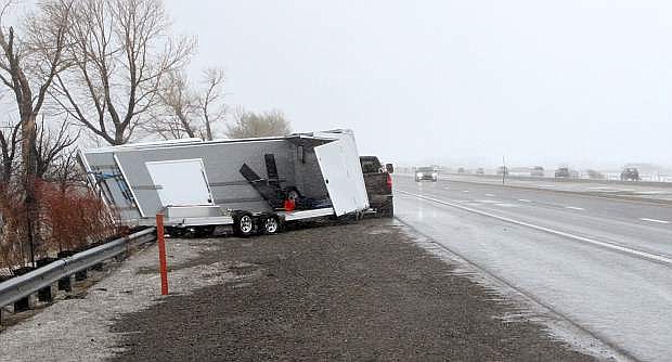
Even with stiff warnings not to, a number of truckers tried to get their rigs through the wind zone. As of 3:30 p.m. there were two 18-wheelers and one RV hauler overturned in the valley.
There were also six big rigs pulled over at the south end of Washoe Valley in the northbound lanes and eight more in the southbound lanes just above the big bridge. Just at the start of the bridge, there was one big rig that was pushed into the concrete barrier but that truck was still on its wheels. The tractor was damaged, stranding the vehicle there.
Sustained winds up to 57 mph were recorded on bridges in the area with an 80 mph gust just north of Washoe City, the National Weather Service said.
At one point more than 6,000 NV Energy customers were without power in and around Reno-Sparks and Carson City, but electricity had been restored to more than half of those by Monday afternoon.
At 3 p.m. on Monday, NV Energy was reporting power outages in Carson City and Douglas County affecting a total of 520 customers.
The three-day winter storm could bring up to 4 feet of snow at Lake Tahoe, as much as 8 feet of snow above 7,000 feet and wind gusts as strong as 140 mph over Sierra ridges.
The National Weather Service in Reno has issued a winter storm through 4 a.m Thursday. Snow totals during that period are expected to range from 2-4 feet at lake level and 4-8 feet above 7,000 feet.
The heaviest snowfall, according to the weather service, is expected Monday night into Tuesday morning and Tuesday night into Wednesday morning. The heavy snow and strong winds will complicate travel in the Tahoe Basin.
Lower elevations will see a mix of rain and snow through the storm. Snow levels will start Monday around 4,500-5,500 feet and then steadily rise the next two days. According to the weather service, snow levels are expected to max out between 6,000-7,000 feet Wednesday before falling Thursday down to the foothills.
The snow from this storm will be heavy Sierra cement, which will increase the potential for large, destructive avalanches in the Sierra backcountry.
The Sierra Avalanche Center has issued an avalanche watch from 5 p.m. Monday to 7 a.m. Thursday.

Comments
Use the comment form below to begin a discussion about this content.
Sign in to comment