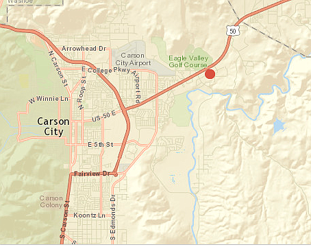
Current outage on Carson City's east side
Through Thursday, a moderate to strong atmospheric river will bring significant precipitation to the region. This storm will be the first true test of the hydrologic system this season after the extreme conditions last season followed by a hot and dry summer and fall, the National Weather Service said.
Creeks and streams in the mountains and foothills are expected to rise rapidly and minor flooding is possible tonight into Thursday. Recent burn scars from the past few years will also bring a higher risk for flooding or possible debris flows.
Mainstem rivers are also expected to rise significantly, but no flooding is currently forecast. Persons living along small creeks and streams should monitor the latest weather information at weather.gov/reno and be prepared to take action should flooding occur.
Sand bag locations are stocked and ready to go at the following locations: Ross Gold Park, next to Fire Station 53 Foothill Drive, off of Winnie Lane Carson City Corporate Yard on Butti WayA high wind warning is in effect until Thursday morning, however the National Weather Service in Reno issued a flood warning on top of the high winds.
Winds will continue from the southwest 25 to 40 mph with gusts up to 70 mph. Wind prone areas could see 70+ mph gusts. Strong cross winds and travel restrictions are likely to impact high profile vehicles especially along Highway 395/Interstate 580. Localized damage to trees and fences may occur along with possible power outages in Western Nevada
Through Thursday, a moderate to strong atmospheric river will bring significant precipitation to the region. This storm will be the first true test of the hydrologic system this season after the extreme conditions last season followed by a hot and dry summer and fall, NWS said.
Creeks and streams in the mountains and foothills are expected to rise rapidly and minor flooding is possible tonight into Thursday. Recent burn scars from the past few years will also bring a higher risk for flooding or possible debris flows.
Mainstem rivers are also expected to rise significantly, but no flooding is currently forecast. Persons living along small creeks and streams should monitor the latest weather information at weather.gov/reno and be prepared to take action should flooding occur.

Comments
Use the comment form below to begin a discussion about this content.
Sign in to comment