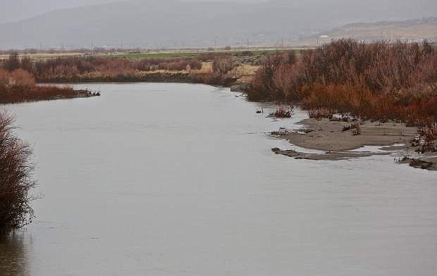
The Carson River southeast of Snyder Avenue is seen swollen to the banks Wednesday morning.
Thursday morning update:
A break in winter weather along with snow covered and icy roads greeted Northern Nevada Thursday morning.
Up to 2 inches of snow fell overnight in parts of Carson and Eagle valleys.
The commute was slick Thursday morning with Nevada Highway Patrol and Carson City Sheriff’s Office helping motorists in need.
Almost all major roads required chains or snow tires. Those restrictions were starting to be lifted as crews were able to clear roads.
A winter weather advisory wraps up at 10 a.m. this morning.
The reprieve could be short however, as a bigger storm is expected this weekend.
A storm expected this weekend is being compared to the 1997 storm that caused extensive flooding throughout western Nevada when warm rains melted the Sierra Nevada snowpack.
“Meteorologists are making the comparison because of the heavy snowfall and considerable snowpack in December 1996, which came before the 1997 ‘Pineapple Express’ or atmospheric river between December 30 and New Year’s 1997,” said Stacey Belt, Carson City deputy emergency manager. “That rainfall in the mountains brought a lot of water down causing flooding across western Nevada. If predictions are accurate and the snow level is between 9,000 and 10,000 feet this coming Saturday, it’s a lot of moisture on top of the snowpack and it has to go somewhere.”
A flood watch is in effect from 4 a.m. Sunday until 8 a.m. Monday throughout the area, including in Carson City, Reno, Gardnerville, Virginia City and Stateline, according to the National Weather Service (NWS).
Rainfall totals of six to 12 inches are possible around the Tahoe Basin and in the Carson Range with up to three inches of rain in the lower elevations around Reno-Sparks, Carson City and Douglas County, the NWS flood alert says.
Sandbags are available at the Public Works corporate yard at 3505 Butti Way, between the Public Works building and Parks Department entrance.
It’s a self-filling station so bring your own shovel, Belt said.
If needed, an evacuation shelter will be designated from several identified shelters in the city, including the Multi-Purpose Athletic Center, Carson High School, the Carson City Community Center, Carson Middle School, Eagle Valley Middle School, Al Seeliger Elementary School and Carson City Fairgrounds/Fuji Park.
In Douglas County:
Kingsbury Grade is still closed. However, Muller Lane reopened on Thursday after a line carrying treated effluent from Lake Tahoe to the East Valley was repaired.
The break in the Douglas County Sewer District No. 1 line occurred around 11 a.m. Tuesday pouring thousands of gallons into the East Fork of the Carson River.
The effluent was on its way to a winter storage pond the district shares with the Minden-Gardnerville Sanitation District. In the summer the effluent is used to irrigate Park and Bently fields.
The Lyon County Sheriff’s Office is advising drivers throughout the county to exercise extra caution on the roadways this morning. All Lyon County communities are reporting overnight snow, and deputies say the roads are pretty slick from the ice and snow. According to our dispatch center there were five weather related accidents over night.
In Churchill County, snow began falling in the Lahontan Valley shortly after 8 p.m. on Wednesday, and accumulations have been reported from 3-4 (updated) inches in the city to as much as 6 inches in the valley and 8 inches in Fernley.
In Tahoe, there are “significant outages” of power in Glenshire, Christmas Valley, Meyers and the West Shore near Tahoma-Emerald Bay due to heavy snow on power lines and strong winds, reported Liberty Utilities on Thursday morning.
Ski resorts around the lake reported anywhere form 15 inches to 2 ½ feet of new snow in the past 24 hours. Heavenly Mountain Resort reported 30 inches in 24 hours Thursday morning. North Shore resorts Squaw Valley Resort reported 23 inches and Northstar California reported 29 inches.
The Tahoe Daily Tribune, Record-Courier and Lahontan Valley News contributed to this report.
•••
Wednesday's print story:
Heavy rain closed some Carson City roads Wednesday and potentially worse weather is on its way.
A storm expected this weekend is being compared to the 1997 storm that caused extensive flooding throughout western Nevada when warm rains melted the Sierra Nevada snowpack.
“Meteorologists are making the comparison because of the heavy snowfall and considerable snowpack in December 1996, which came before the 1997 ‘Pineapple Express’ or atmospheric river between December 30 and New Year’s 1997,” said Stacey Belt, Carson City deputy emergency manager. “That rainfall in the mountains brought a lot of water down causing flooding across western Nevada. If predictions are accurate and the snow level is between 9,000 and 10,000 feet this coming Saturday, it’s a lot of moisture on top of the snowpack and it has to go somewhere.”
A flood watch is in effect from 4 a.m. Jan. 8 until 8 a.m. Jan. 9 throughout the area, including in Carson City, Reno, Gardnerville, Virginia City and Stateline, according to the National Weather Service (NWS).
Rainfall totals of six to 12 inches are possible around the Tahoe Basin and in the Carson Range with up to three inches of rain in the lower elevations around Reno-Sparks, Carson City and Douglas County, the NWS flood alert says.
The Carson River will enter flood watch stage midday Jan. 8, continuing for approximately 24 hours, according to Belt.
She said Carson City is officially at the flood monitoring alert stage as defined by the city’s Emergency Operation Plan.
“Our focus remains public safety and making good use of the next 48 hours to review plans and procedures, and be prepared to move to heightened status as the situation dictates,” she said.
Sandbags are available at the Public Works corporate yard at 3505 Butti Way, between the Public Works building and Parks Department entrance.
It’s a self-filling station so bring your own shovel, Belt said.
If needed, an evacuation shelter will be designated from several identified shelters in the city, including the Multi-Purpose Athletic Center, Carson High School, the Carson City Community Center, Carson Middle School, Eagle Valley Middle School, Al Seeliger Elementary School and Carson City Fairgrounds/Fuji Park.
On Wednesday, Highway 50 west from Highway 395 to State Road was closed for several hours in the morning due to multiple cars spinning out on the road, according to the Nevada Highway Patrol.
Curry Street from Rhodes Street to Lake Glen Drive was open only to local traffic until 1:30 p.m. due to flooding caused by an obstructed culvert pipe, according to the Carson City status map at carson.org.
Flooding was also reported across Nye Lane at North Carson Street.
The rain was expected to turn to snow overnight and become a mix of rain and snow on Thursday with an accumulation of less than a half inch possible, according to NWS.

Comments
Use the comment form below to begin a discussion about this content.
Sign in to comment