4:50 p.m. The National Weather Service is reporting that the Dayton retention pond is receiving and there is no longer a threat for the pond to fail. The NWS issued the statement after talking to Lyon County Emergency Management.
•••
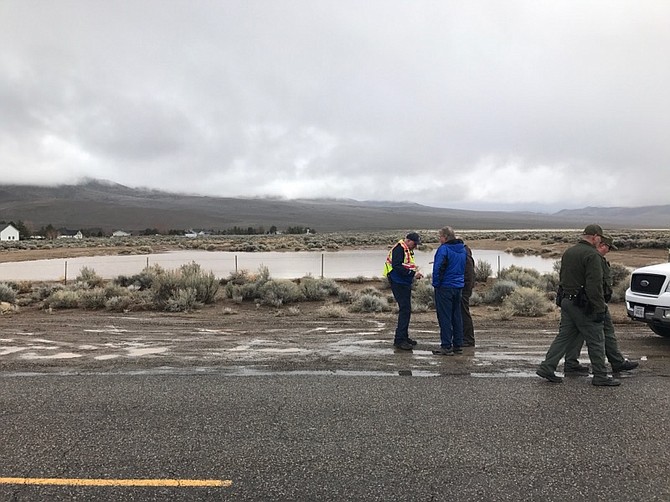
1:45 p.m. Lyon County officials are clarifying an emergency alert that was sent out by the National Weather Service and other organizations Tuesday afternoon.
Officials on scene are not evacuating any residents.
Lyon County Manager Jeff Page said there has been NO dam failure.
"A storm water retention basin located south west of Dayton Valley Road is full and over flowing into drainages," Page said. "Currently there are no homes or property threatened. There is potential that could change in the next few hours."
Officials are letting residents in and out of the area to get to their home but are turning away the public.
•••
An emergency alert has been issued urging east Dayton residents, East Dayton including, but not limited to, these streets...Comstock, Sutro, Dayton Valley Road to evacuate.
"There has been NO dam failure," Lyon County Manager Jeff Page said in a statement at 1:39 p.m. "A storm water retention basin located south west of Dayton Valley Road is full and over flowing into drainages. Currently there are no homes or property threatened. There is potential that could change in the next few hours."
The south Dayton retention pond is expected to fail at any time triggering a flash flood warning.
The failure is expected to send between 2 and 4 feet of water into Dayton within 2 to 3 hours of failure. "Move to higher ground now. This is an extremely dangerous and life-threatening situation. Do not attempt to travel unless you are fleeing an area subject to flooding or under an evacuation order," said the National Weather Service in Reno. ••••••
A flood warning for urban areas and small streams remains in effect until 11:30 a.m. today. Heavy rain ended around 4:30 a.m., according to the National Weather Service, but many small streams are out of their banks.
The Carson River is currently at 6.58 feet and is expected to crest about 8.4 feet about 10 p.m. tonight. The 8.4 feet is far below the 11.98 feet the river reached on Feb.11 and 11.04 feet it reached in January.
At 8:30, it is currently snowing in Reno and Washoe Valley but it clears up when you start coming down from Lakeview Hill into Carson City.
The wind advisory will stick with us until 4 p.m. today with gusty winds 20-30 mph expected this morning in Western Nevada. Fish Springs saw a wind gust of 54 mph earlier this morning and it’s still gusting to 40 mph out there.
The East Fork at Markleeville crested right at action stage of 6 feet and has been receding for the last couple of hours. The West Fork at Woodfords stayed well short of flood stage through the night.
The main stem of the Carson looks like it’s preparing to crest at 6.43 feet. That means Cradlebaugh and the rest of the bridges should be safe from flooding today at least.
We might see snow in the Valley later today. Expect a high near 40 mph with breezy conditions. Don’t expect to see the snow accumulate.
In Lyon County, workers their installed two additional culvert pipes on River Road near Cardelli. County Manager Jeff Page said the work allowed water to move under the road more efficiently. Even with this improvement water went over the road overnight.
“Crews are currently waiting for the water to recede in parts of Dayton and Stagecoach to fix access to residents so they can get in and out of their properties safely.
Opal Road, Topaz, Boyer, Silver Lane, Black Hawk and Iron Mountain have significant water flows.
All drainages are flowing unimpeded but there is more water than drainage capacity. Crews will be working throughout the week to make roads passible. Permanent repairs may take several months.”
Mt. Rose Highway is still closed after an avalanche was reported about 9:15 p.m. Monday. There’s no estimate on when it will reopen.
Nevada Highway Patrol Trooper Dan Gordon said Tuesday there are no immediate reports that any motorists or vehicles were trapped in the snow slide near the crest. It is reported there’s some 20 feet of snow
Gordon says it’s still snowing and driving conditions are treacherous in higher elevations throughout the Sierra Nevada, including Interstate 80.
He says vehicles must have chains or snow tires on all mountain passes.
•••
TUESDAY’S PRINT STORY: When it rains, it pours — especially when the region scores its average annual rainfall.
With Monday’s storm, we’re at more than 10. 5 inches year-to-date, and rising. The average is 10.56 inches, according to the Western Regional Climate Center.
Monday’s storm dropped close to 1.5 inches of rain pushing the total close 4 inches for the month unofficially as it still was raining as of press time.
Torrential rain and strong winds with warnings in effect until this afternoon. The wind advisory remains in effect until 4 p.m. The forecast predicts winds increasing 25 to 35 mph with gusts up to 80 mph in wind-prone areas.
The flood warnings remain in effect until 11:30 a.m. for Carson City, northern Lyon County, Douglas, Washoe and Storey counties
Monday was calm for the Carson River as it hovered at 5.58 feet, which is well below flood concerns. The river was supposed to crest at 8.4 feet late tonight. However, the NWS said small creeks and streams with poor drainage areas are still at risk for floods and mudslides, as low-lying spots cause water runoffs.
The second major storm this month comes less than 10 days after flooding damaged homes, businesses, and washed out roads in the region — the latest in a series of record-breaking winter storms in the area. The latest storm caused about $1 million to $1.5 million in property damages to Carson City. In January, there was about $3.3 million worth of damage done in the city, Carson City officials have said.
Regionally, the January $15 million in damages from winter storms in January that led President Donald Trump to issue a major disaster declaration.
In Reno, the Truckee River was forecast to crest today at 9.4 feet, according to readings from The National Oceanic and Atmospheric Administration. The Truckee hit 12 feet in January and 11.65 feet earlier this morning.
The NWS issued a flood warning for the region amid heavy rainfall and a winter storm warning in the Sierras.
Those who traveled through the mountains were either barricaded by road closures due or spent commute time by installing chains along state borders for highways. I-80 westbound was closed at the California-Nevada state line for most of Monday afternoon and evening, reopening close to 7 p.m. It was closed again, less than an hour later.
More snow is expected to pack on throughout the day and will linger into Wednesday morning. Forecasters say the winter storm could drop up to 5 feet of snow in areas above 7,500 feet while lower elevations could see between 8 and 24 inches of snow. High avalanche danger warnings are in effect until Tuesday from Yuba Pass to Ebbetts Pass.
Moderate to heavy rain along with snowmelt below 7,000 feet was expected to swell rivers and streams and increase the chance of flooding.
The weather continues to hit California vigorously, according to Associated Press. In the San Joaquin Valley, residents were patrolling levees for signs of danger, reviewing evacuation plans and filling hundreds of sand bags as the San Joaquin River kept rising. Emergency plans were in effect for the private neighborhood of 800 homes.
Santa Cruz County had seen 2.8 inches of rain in 24 hours and could see up to 8 inches before the storm passes Tuesday. Marin County got 2.3 inches of rain while close to an inch fell in San Francisco.
For those in San Francisco, the region also surpassed the normal annual amount for the wet season that begins in October. The city has logged 24.50 inches of rain since then, said NWS.
The water level also kept falling at Oroville Dam, where a damaged spillway had raised major flood concerns and prompted the evacuation of 188,000 people a week ago.
Looking ahead, the NWS said another storm is forecast this weekend with colder temperatures, possibly snow.
The Associated Press contributed to this report.

Comments
Use the comment form below to begin a discussion about this content.
Sign in to comment