BRAD HORN/NEVADA APPEAL Cars drive slowly and with headlights near Flint Drive in Carson City on Sunday.
Associated Press
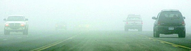
RENO - Another foggy morning cloaked Northern Nevada to begin the week, with visibility as low as one-eighth of a mile in Fallon, a quarter of a mile in Reno and three-quarters of a mile in Winnemucca.
But forecasters said it's about over.
At least, for the time being.
Rising winds and an approaching storm system today should blow away the temperature inversion that has trapped fog in the Truckee Meadows, Carson City and the Lake Tahoe Basin for the last eight days straight, according to the National Weather Service.
"Thank goodness. I'm ready to see some sunshine," said Jessica Kielhorn, a weather service technician in Reno.
The foggy siege continued at the Reno airport on Sunday, with 33 flights canceled. Flight operations started returning to normal after the fog began burning off at noontime. The problems returned overnight along with the fog.
Since the fog first started causing problems late Jan. 16, more than 300 flights at the Reno airport have been canceled, with many more delayed, according to spokeswoman Trish Tucker. The cancellations have affected nearly 190,000 passengers.
"We are looking for Mother Nature to give us a reprieve," she said. "It's been frustrating - not only for the airport and the airlines - but most importantly for the passengers. This isn't normal."
The problem resulted from a combination of temperature inversions and deep snow left from record snowstorms that buried the region in snow in late December and early January. Moisture from melting snow rises into the air during the day only to freeze at night, creating blinding fog that is trapped by the inversions.
Forecasters Sunday said winds were rising at 18,000 feet in advance of the coming storm.
Rain and mountain snow were expected today and Wednesday, and after a break on Thursday, another round of rain and snow was expected Thursday night into Friday, forecasters said. Snow levels are expected to start between 6,000 and 6,500 feet and lower to around 5,000 feet by Wednesday.
Sunshine is expected by the weekend, with a possibility of another foggy go-round early next week.

Comments
Use the comment form below to begin a discussion about this content.
Sign in to comment