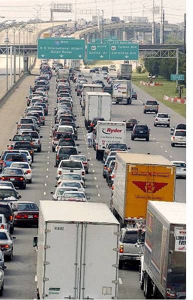
Interstate 10 is jammed with traffic as people leave New Orleans Tuesday afternoon, Sept. 14, 2004. Many residents are evacuating the city in advance of the possible arrival of Hurricane Ivan. (AP Photo/Bill Haber)
NEW ORLEANS (AP) - Stragglers streamed toward higher ground Wednesday on highways turned into one-way evacuation routes as Hurricane Ivan roared toward the Gulf Coast with 135 mph wind, pounding beaches with 12-foot waves and starting to deliver what could be torrential rain.
Ivan could cause significant damage no matter where it strikes, as hurricane-force wind extended up to 105 miles out from the center. Hurricane warnings were posted along a 300-mile stretch from Grand Isle, La., across coastal Mississippi and Alabama to Apalachicola, Fla., but Ivan had turned onto a northerly course, generally toward the center of the warning area, the Alabama and Mississippi coasts.
"We're leaving today. All this is going under," said surfer Chuck Myers who was only taking pictures of the waves Wednesday morning at Gulf Shores, Ala. "We surfed it all day yesterday. It was glorious."
"This is a bad one and people need to get out," Mobile, Ala., Mayor Mike Dow said Wednesday on ABC's "Good Morning America."
Deputies went door-to-door through the night in south Mobile County, instructing residents to evacuate. Some are expected to remain, Sheriff's Sgt. Steve Kirchharr said, but overall "we have received a good response."
Interstate 65 in Alabama was turned into a northbound-only evacuation route Wednesday morning from the harbor city of Mobile to Montgomery. Chemical plants and refineries around Mobile Bay had been closed down.
Ivan could be the worst hurricane to hit Alabama since 1979, when fast-moving Frederic devastated the coast by splintering hundreds of homes and businesses. Ivan was moving slower than Frederic, increasing the possibility of serious flooding from prolonged rainfall and damage from wind damage.
Roughly 2 million people had been urged or ordered to leave coastal areas, including more than 1.2 million in the New Orleans metropolitan area.
Forecasters said that although Ivan, which killed at least 68 people in the Caribbean, had weakened very slightly to 135 mph Wednesday, it was still an "extremely dangerous category 4 hurricane," and its strength could fluctuate before it crashes ashore early Thursday morning somewhere along the Gulf Coast.
After making landfall, Ivan threatened to stall over the Southeast and southern Appalachians, with a potential for as much as 20 inches of rain. "Unfortunately for western North Carolina, it's a worst-case scenario," said Neil Dixon of the National Weather Service office in Greer, S.C. That region had already been thrashed by the remnants of Hurricane Frances.
Twelve-foot waves already were booming ashore Wednesday morning at Gulf Shores, Ala., and starting to erode the beach. Rain had started falling along the Florida Panhandle and the Alabama coast. A buoy about 300 miles south of Panama City registered waves just over 34 feet high early Wednesday.
"This is the first time I've seen waves this big and we've been coming here for years," said Terry Kilpatrick of Winston County in north Alabama, who was boarding up windows on his condominium units at Gulf Shores.
At 2 p.m. EDT Wednesday, Ivan was centered about 170 miles south of the Alabama coast and was moving north at 14 mph. Forecasters said Ivan could produce a coastal storm surge of 10 to 16 feet, topped by large waves.
Everyone from New Orleans east to Apalachicola, Fla., should be worried because even the tiniest change in the storm track could move the location of the storm's landfall by hundreds of miles, said Hector Guerrero, a meteorologist at the National Hurricane Center.
"Even a little jog could result in considerable change," he said Wednesday.
And although Ivan's northerly track suggested landfall would be east of New Orleans, Mayor Ray Nagin warned that hurricane-force wind still could strike the region.
"We're not quite out of the woods," Nagin said, although he said flooding from Lake Pontchartrain was no longer believed to be a major threat.
The city opened the Louisiana Superdome to people with medical problems that kept them from evacuating. All bridges out of the city were ordered shut down because of the threat of high wind, and Police Chief Eddie Compass imposed a 24-hour curfew as of 2 p.m.
The Red Cross said extra shelters were opened in the Jackson, Miss., area because evacuees had trouble finding places to stay. Hotels were booked as far north as Memphis, Tenn., some 325 miles north of Mobile, and parts of Arkansas.
No shelters were available in Baldwin County, Ala., said assistant emergency management director Roy Wulff. The county usually uses schools as shelters, but the wind expected from Ivan "far exceeds the winds those buildings were built to withstand," he said.
Streets were all but deserted Wednesday morning in Fort Walton Beach, Fla., and along Mississippi's 75-mile coast, and most homes and businesses, including a number of gas stations, were boarded up.
But at Perdido Key, on the Alabama-Florida state line, a steady stream of drivers stopped along U.S. 98 to look at the churning surf. "This is almost a once-in-a-lifetime view," said Glen Phillips, who has lived in the area since 1967.
New Orleans is particularly vulnerable to flooding. Up to 10 feet below sea level in spots, it sits between the nearly half-mile-wide Mississippi River and Rhode Island-size Lake Pontchartrain, relying on a system of levees, canals and huge pumps to keep dry.
The city has not taken a major direct hit since Betsy in 1965, when an 8- to 10-foot storm surge submerged parts of the city in 7 feet of water. Betsy was blamed for 74 deaths in Louisiana, Mississippi and Florida.
Some people said they wanted to stay to witness the storm's wrath firsthand.
"There's nothing like a severe storm to put a human being in their proper place," said Prentice Howard, 59, stationed at Naval Station Pascagoula in Mississippi. "I want to experience the power of nature. It sounds dumb to some people but that's the way it is. Sort of like skydiving."
Meanwhile, Tropical Storm Jeanne, with wind of 70 mph, was passing over Puerto Rico on Wednesday and was threatening to turn into a hurricane. The hurricane center said its center made landfall near Yabucoa, in southeastern Puerto Rico. At 2 p.m. EDT, it was about 25 miles south-southeast of San Juan. Long-range forecasts showed it could be near Florida's east coast as early as the weekend.
---
Associated Press writers Jay Reeves in Gulf Shores, Ala.; Garry Mitchell in Mobile, Ala.; Bill Kaczor in Perdido Key, Fla.; Allen G. Breed and David Royse in Panama City Beach, Fla.; Shelia Hardwell Byrd in Biloxi, Miss.; and Mary Foster in New Orleans contributed to this report.
---
On the Net:
National Hurricane Center: http://www.nhc.noaa.gov

Comments
Use the comment form below to begin a discussion about this content.
Sign in to comment